Showing posts with label Ewa Plantation. Show all posts

Monday, July 27, 2015

Ewa Plain Major Hawaiian Burial Place - Federal TCP Documents

Under Former Ewa Plantation Lands, Hoopili, And 

HART Rail Stations

 Are Tens Of Thousands Of Iwi Kupuna Burials 


Kanehili Cultural Hui Report - John Bond 


The Leina a ka ‘uhane And Association With Major Native Burials In West Oahu


“Maly reflected that, given the history of the countryside, it would be more unusual not to find iwi than to find them”. June 23, 2011, Section 106 Programmatic Agreement (PA) Traditional Cultural Properties (TCP) Study Meeting

— William Aila, Hui Malama (before becoming DLNR Chair and now DHHL deputy.)
“People have estimated that there were 800,000 to a million people living here when Westerners arrived [in Hawaii in 1778]; some people estimate it was much higher—that’s one era,” says William Aila, a board member of Hui Malama. “You have many generations prior to that. A lot of people were born and died all over these Islands. They don’t just disappear.”

Figures from: IDENTIFICATION OF NATIVE HAWAIIAN TRADITIONAL CULTURAL PROPERTIES, Tuggles, Maly, etc., March 2001. (more documents further below)


IDENTIFICATION OF NATIVE HAWAIIAN TRADITIONAL CULTURAL PROPERTIES

by H. David Tuggle, Ph.D. M.J. Tomonari-Tuggle, M.A. with the collaboration of Maria E. Ka‘imipono Orr, Kepâ Maly Kumu Pono Associates, and Kalani Flores Mana ‘o‘i‘o Principal Investigator: Thomas S. Dye, Ph.D.
International Archaeological Research Institute, Inc.
Hawai‘i  March 2001

EXCERPTS:

“The main trail around O‘ahu passed through this populous area (‘I‘i 1869 [1959:96]). From the Waikîkî side, entering into ‘Ewa along the trail entailed crossing the leaping place of souls called Leilono, which was guarded by demons (see Kapûkakî, below). From the west, entering into ‘Ewa meant passing through the plain of Kaupe‘a, a place of wandering souls.”

Burials from the pre-contact and post-contact eras are known to occur over the entire ‘Ewa Plain, in sinkholes, platforms, and dune deposits (Tuggle and Tomonari-Tuggle 1997b). There is also a 19th century reference to chiefly burial that suggests there were places of interment for ali‘i at Pu‘uloa (Alexander 1906:27).

“The potential TCPs on Navy retained lands at former NAS Barbers Point include the plain of Kaupe‘a and the locale of Kualaka‘i. These places meet general NRHP criteria (see Section I.3.1). Connections can also be made among Kualaka‘i, the plain of Kaupe‘a, and Pu‘uokapolei, and their association with Kahiki” (see Johnson 1988; Tuggle and Tomonari-Tuggle 1997b:27-29).

II.2.3.1. THE PLAIN OF KAUPE‘A 

The plain of Kaupe‘a was located on what is today called the ‘Ewa Plain. It probably includes the housing areas and the golf course in the Navy retained lands. Kaupe‘a (see Fig. 3 for location) has potential cultural significance under the following NRHP criteria:

(a) it is associated with traditional events and patterns of events, as expressed in its identification as the ao kuewa (place of homeless souls) for the island of O‘ahu; it is also identified as a place for the collection of plants used for a special lei.

(b) it is associated with the lives of persons significant in the past, as found in the traditions of Hi‘iaka.

It is associated with the lives of persons significant in the past, as found in the traditions of Hi‘iaka, has symbolic associations with Kahiki, ancestry, and the generations of ‘Ewa.

II.2.1.1. THE PLAIN OF KAUPE‘A AND KÂNEHILI

A place of many pits with human bones describes most of the great expanse of the ‘Ewa Plain, where limestone sinkholes were used for human interment over many centuries (including the post-contact period, see below). In many cases, human remains were placed on the floors of the sinkholes (not buried) with the bones thus visible when one looked into the pit, surely a setting to inspire association with spirits of the dead.

Each island had at least one place for wandering souls. For O‘ahu, this place was the plain of Kaupe‘a. Kamakau (1870 [1964:47], italics original) writes that Kaupe‘a was known as: …ao kuewa, the realm of homeless souls,…also called the ao ‘auwana, the realm of wandering souls. When a man who had no rightful place in the ‘aumakua realm died, his soul would wander about…

(The association of Leiolono with Kaupe‘a:)

According to Kamakau (1870 [1964:47-49]), the ao kuewa was one of the three places of the dead, the others being the realm of the ancestral spirits (ao ‘aumakua) and the realm of Milu, the place of endless night (pô pau ‘ole o Milu). Across the Pu‘uloa lagoon from Kaupe‘a was a place known as Leilono, which is located on the ridge dividing ‘Ewa and Kona districts (discussed below under Kapûkakî). It was at Leilono where the spirits of the dead leapt from the branches of a supernatural breadfruit tree, separating to go to one of the three realms. Those who had no help from ‘aumakua would end up friendless (po‘e ‘uhane hauka‘e), wandering the plain of Kaupe‘a catching moths and spiders.

Although the boundaries of the plain of Kaupe‘a are not clearly defined, it certainly occupied a substantial portion of the ‘Ewa Plain, including the area next to Pearl Harbor lagoon and the area of former NAS Barbers Point. Kamakau (1870 [1964:47-49]) describes the plain as “beside Pu‘uloa,” and as a place of wiliwili trees, which is a common tree on the dryland limestone of ‘Ewa. In the tradition of Pele and Hi‘iaka (Emerson 1915:167; Keonaona and S.L. Desha Sr. et al. 1927, in Maly Appendix B), the plain is described as extending from “the wiliwili trees…to Kanehili” (Ke Au Hou 1911, in Sterling and Summers 1978:44), and as back of Keahi and Pu‘uloa (Pukui 1943:59).

“At the same time, it is clear from Manu’s description quoted above, as well as many other references, that the plain of Kaupe‘a (and associated places of the ‘Ewa Plain) was much more than just a place of ghosts.”

“It is a place of stark beauty and great contrasts, captured in versions of the Pele and Hi‘iaka story” (Emerson 1915:166ff; Keonaona and Desha Sr. et al. 1927, in Maly Appendix B) and in the chant for Kûali‘I (Kapa‘ahulani, in Fornander 1916:390; 1919:458). Part of the beauty of Kaupe‘a is in the plants used to make a famous lei, as described in a song of Hi‘iaka “addressed to Lohiau and Wahine-oma‘o” (Emerson 1915:167.
 
It is possible that Kaupe‘a refers to the ‘Ewa Plain as a whole. This is suggested in a comparison of the repetition of place names and related features (primarily vegetation and springs) in the Pele and Hi‘iaka traditions, as well as in the chant for Kûali‘i (Kapa‘ahulani, in Fornander 1916:390; 1919:458). The following section from the tradition of Makanikeoe (Manu 1895, May 10, in Maly Appendix B) provides a substantial associative context for Kaupe‘a and the ‘Ewa Plain being synonymous:

Makanikeoe then departed from this place, turning to the plain of Puuloa. He passed many pits in this place where the bones of men have been left. He then followed the trail to the breadfruit tree, Leiwalu, at Honouliuli. This is the breadfruit tree of the expert sailor, Kahai, so told in his story:

There are also many pits in which were planted sugarcane and bananas, and planting mounds. He also saw manu oo (honey creepers) sipping the nectar of noni blossoms. There were also two ducks that had gone into a pit, and with a great strength, they were trying to push a stone over, to hide the pit. This Makanikeoe knew what the ducks were trying to do. They wanted to hide a spring of water which flowed underground there. It is this spring which in calm times could be heard, but not found by the people who passed through this area.

Parker and King (1990:9; emphasis added) elaborate on this by noting: Thus a property may be defined as a ‘site’ as long as it was the location of a significant event or activity, regardless of whether the event or activity left any evidence of its occurrence. A culturally significant natural landscape may be classified as a site, as may the specific location where significant traditional events, activities, or cultural observances have taken place…A concentration, linkage, or continuity of such sites or objects, or of structures comprising a culturally significant entity, may be classified as a district.

I.3.4.2.1. Place as Tangible Property

To qualify for the NRHP, a property must be a “tangible property—that is, a district, site, building, structure, or object” (Parker and King 1990:9). However, a tangible property does not have to be a constructed one, under the NR definition of “site” (from NR Bulletin 16, quoted in Parker and King 1990:9): …the location of a significant event, a prehistoric or historic occupation or activity, or a building or structure, whether standing, ruined, or vanished, where the location itself possesses historic, cultural, or archaeological value regardless of the value of any existing structure.

Parker and King (1990:9; emphasis added) elaborate on this by noting: Thus a property may be defined as a ‘site’ as long as it was the location of a significant event or activity,

regardless of whether the event or activity left any evidence of its occurrence. A culturally significant natural landscape may be classified as a site, as may the specific location where significant traditional events, activities, or cultural observances have taken place…A concentration, linkage, or continuity of such sites or objects, or of structures comprising a culturally significant entity, may be classified as a district.


Rail Lawsuit Requires Identification Of All Traditional Cultural Properties

FTA and HART Failed To Recognize 

Federal Judge Ruling On Rail Route TCP's


FTA and HART Rail Misrepresent The True Ewa Honouliuli Native Hawaiian Spirit Pathway

Honouliuli Ewa TCP's Are Important Wahi Pana (Sacred Places) On Multi-Dimensional Levels

Honouliuli Ewa's Makakilo Kalo'i Gulch - A Rare In Depth Survey Of This Important Cultural Property


Friday, May 29, 2015

Ewa Plantation Prime Ag Land Still Retains Centuries Old Traditional Agricultural Features

Ewa Plantation Prime Ag Land Still Retains Centuries Old Traditional Agricultural Features

by John Bond   Kanehili Cultural Hui


The original field numbers and layouts are still used for the farmland under production today growing nearly 40% of Oahu's fresh vegetables.

Plantation roads, old railway beds, water flumes, concrete bridges from the 1920's, still working water plantation pipes and pump station, electrical lines, designated by the State Office of Planning as PRIME and Class A & B soils. 


It was the 1977 Oahu General Plan (OGP) that caused the 1978 Hawaii Constitutional Convention to craft Article XI, Section 3 to make it CLEAR that Important Agricultural Lands should be mapped and preserved.

The thinking then was towards "diversified agriculture" that would replace sugar and pineapple as the plantations closed down.

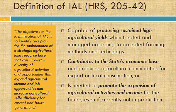
In fact the State of Hawaii DID meet the constitutional requirement to map the Important Agricultural Lands (IAL) as the Hawaii State Office of Planning ALISH and LSB maps illustrate.


State of Hawaii did meet the constitutional requirement to map the Important Agricultural Lands.These are the maps!

And in fact the City Council also passed a resolution in 2012 supporting the mapping of the IAL even if in an urban growth boundary, but City political manipulation and the usual developer payoffs pushed the incredibly bad Bill 3 zoning FIRST which was contrary to the intent of the Hawaii State Constitution.

Very bad planning with no regard for the sustainability needs of the West Oahu community and definitely NOT SMART GROWTH. 


Of all the places that needs an emergency food supply it is Oahu and especially dangerously isolated West Oahu...

Honolulu City Council members used as an excuse the 1977 Oahu General Plan which designated West Oahu as an urban growth area as "the reason"  to pave over all agricultural lands and eliminate open space. 


Under IAL criteria it meets SEVEN of eight but was never meant to be EXCLUDED. It's a CORRUPT City government land development EXCUSE.

There was NOTHING in the 1977 OGP passed by the City Council that stated that agriculture could NOT be in the West Oahu urban growth area and that it must all be paved over. 

Productive diversified agriculture open space was expected in 1977-78 to also provide a beneficial scenic environment for the West Oahu community and cultural connection with the aina. As most people know who have traveled anywhere - passing through agricultural farmland by car, bus or train provides a pleasant and memorable experience for residents and visitors alike.


Important Agricultural Lands criteria wasn't a 
City Scheme Political Boundary 

IAL workshops conducted by the City DPP consultants found that those honestly interested in identifying Important Agricultural Lands picked the three MOST IMPORTANT qualifications for IAL- and the politically created "urban growth boundary" scored consistently VERY LOW! 

From the Hawaii State governor on down in 1978 it was important that Oahu RETAIN open space and some agricultural character which would also be attractive for tourism industry visitors to experience. 

In 1978 those political leaders of intelligence knew that visitors didn't come to Hawaii to see VAST URBAN SPRAWL. Hawaii's cultural history is based upon AG.

The diversified fresh produce agriculture serving local markets and restaurants which exists on former Ewa Plantation today is EXACTLY what the 1978 ConCon had in mind to preserve- productive, job creating open space and a rural character which was the essence of the Hawaii State motto - the Life of the Land...


There will be NO LIFE in the land that is paved over and dumping huge amounts of polluted surface water runoff into nearby swimming beaches, surfing and fishing spots. 

An H-1 car accident or the failure of a simple mechanical part can create a massive highway traffic nightmare of nearly unbelievable proportions, and in a matter of minutes force thousands of cars and heavy trucks to divert through local community roads. 

Unfortunately the elderly and very young children as well as pets are at great risk during these massive endless traffic jams. Fire and emergency vehicles, service vans and food deliveries can't get through. 

This is what is coming to West Oahu... and it will be an 
environmental and social disaster.

It has been elected and appointed officials and City government corruption which has sold out the environment and public welfare as well as violating the State Constitution. 

It is the greatest of all CON JOBS to say its "Smart Growth" and postulate that rail will solve traffic problems because local residents will be walking and bicycling everywhere without need to make timely family and business appointments. 


Heavy traffic and endless rows of buildings and strip malls are why people leave.
West Oahu is rapidly becoming a greedy land development scheme for near term land flipping profiteers that will leave local residents high costs and concrete.

There are in FACT already plenty of vacant empty lots in Kapolei that could have supplied the really needed "Smart Growth" low cost, low income apartments that most working families now need and could afford. 

In FACT over 50,000 homes have already been approved in West Oahu to give carpenters and construction workers decades of job security.  


Turning both H-1 and local Ewa roadways into a nightmarish HELL is really a crime against the West Oahu community that will become a future national example of a botched and greed driven "Second City" created by a corrupt political system

West Oahu Residents Speak Out At Important Ag Lands And Hoopili Station Meetings


FTA and HART Rail Misrepresent The True Ewa Honouliuli Native Hawaiian Spirit Pathway


Honouliuli Ewa TCP's Are Important Wahi Pana (Sacred Places) On Multi-Dimensional Levels


Honouliuli Ewa's Makakilo Kalo'i Gulch - A Rare In Depth Survey Of This Important Cultural Property


Monday, April 13, 2015

Ewa Farmland Conversion Impact Rating

Ewa Farmland Conversion Impact Rating

John Bond,       Kanehili Cultural Hui


HART Rail Covers Over 1000 Year Old Ewa Farmland, Top Rated Volcanic Alluvial Soil

This correspondence to FTA is specifically about the Farmland Conversion Impact Rating that was applied to the Honouliuli Ewa Plain farmland which is now planned to have three transit stations and Transit Oriented Developments as part of the FTA funded Honolulu Authority Rapid Transit (HART) system.

The issue is that the Farmland Conversion Impact Rating done by the contracted project engineering company was erroneous, very possibly intentionally so, which resulted in no subsequent important prime farmland mitigation.


This led to the HART rail project constructing an elevated fixed guide way through this very important farmland. FTA may argue that the guide way itself has a “de minimus” (no or minimal effect) impact on this traditional agricultural farmland, however the next planned rail construction phases are three stations and planned TOD’s: East Kapolei, UH-West Oahu and Hoopili.

The impact on the important agricultural lands will be very severe and essentially destroy them forever. FTA is funding this farmland destruction and it certainly isn’t a “de minimus” impact.   

Kanehili Cultural Hui (KCH), HART PA consulting party had identified a very important Section 4f discrepancy with the “Farmland Conversion Impact Rating” (NRCS-CPA-106) a fundamental requirement and farmland rating document for all Federally funded transit corridor type projects which uses prime or unique agricultural land.

As a consulting party Kanehili Cultural Hui (KCH) specifically brought this issue up at the Annual HART Programmatic Agreement meeting on Monday, March 2, 2015 at the HART Ali`i Place, Suite 150 conference room to discuss Implementation of the PA over 2014 and planned activities for 2015.

During that meeting KCH president John Bond asked Ted Matley of FTA if the West Oahu Farrington Highway (WOFH) Farmland Conversion Impact Rating decision could be revisited again because of very credible evidence that the Farmland Conversion Impact Rating was very erroneous and quite possibly intentionally so.

Area of Potential Effect - APE for West Oahu Farrington Highway (WOFH)

******************************************************************** 

What is a 4(f) "use"?

 In discussing 4(f), "use" may mean either a direct use or constructive use. A direct use occurs when land is permanently incorporated into a transportation facility or when there is a temporary occupancy of land that is adverse to a 4(f) resource. Constructive use occurs when a project's proximity impacts are so severe that the protected activities, features, or attributes that qualify a resource for protection under Section 4(f) are "substantially impaired".


TCPs are “places of religious and cultural significance” (NHPA Section 101 and NHPA regulations, Section 106). NHPA guidance (Parker and King 1990:1) defines a TCP as a property “… that is eligible for inclusion in the National Register because of its association with cultural practices or beliefs of a living community that (a) are rooted in that community’s history, and (b) are important in maintaining the continuing cultural identity of the community.” TCPs derive their importance from the practices or beliefs of a community because they are integral to the community’s history and identity. The people who are best able to identify these places and their importance are the members of the community that understand their value.

***************************************************************************************************

KCH has done extensive auditing of the HART rail project’s handling of historic and cultural issues and has found several discrepancies and previously overlooked Traditional Cultural Properties and one with a very erroneous boundary to achieve a “no effect” on the project Area of Potential Effect (APE). There is substantial evidence that the HART rail project’s consultants intentionally misrepresented important APE decisional information to push construction forward.


The KCH analysis is twofold: 1. The original very low farmland rating document done by rail contractor Parsons Brinkerhoff does not reflect the obvious reality of the Ewa Plain farmland based on observation and known published criteria of what constitutes prime or valuable Oahu farmland in Hawaii. Our shared drive links provide the documents, maps and photos to support this analysis.

KCH: 2. The value of the Ewa Plain farmland must be seen in the full context of both ancient and modern Hawaiian cultural values- ahupua’a (mountain to sea) as well as why it was a 1000 year old continuously used Traditional Cultural (Agricultural) Property. How could a traditional native Hawaiian agricultural society based upon Konohiki (deeply skilled land and water management) support the largest pre-western population on Oahu if these lands weren’t among the very best on the island?
These Ewa farmlands were the major native Hawaiian population center because of the rich volcanic soil, fresh spring water and very abundant sunshine. And to this very day these same prime and valuable farmlands support large scale agricultural production.

FTA support for important farmland destruction is a social and environmental injustice and not Smart Growth. Instead of rail transit the Ewa Plain community is getting massive new urban sprawl, vast environmental damage, a huge increase in highway traffic and an important food security safeguard completely eliminated.


It should not ever be forgotten that during the early Honolulu rail design and engineering process there was an enormous amount of political pressure (and still is) placed on government agencies and employees to “get on board” and not be the odd nail that needs to be hammered down by powerful land development interests that want rail construction moved forward as fast as possible, no matter what had to be done to make that happen. 

At the time key project reviews were being made the State Historic Preservation Division was in a very weak and understaffed situation and considered the worst SHPO in the United States- on verge of being shut down and taken over by the NPS.
 

It is no surprise to see that the very flawed Farmland Conversion Impact Rating form was run through with few if any questions asked

KCH asks: How could the Hawaiian Island’s largest and most profitable sugar plantation – Ewa Plantation, thrive and prosper for over 100 years on the Ewa Plain if it didn’t have an ideal combination of abundant sunshine, pure spring water and rich Waianae volcano soil (rated A and B quality) which caused it to be an agricultural powerhouse?

Please review the link to the Historic Ewa Villages which show that the Ewa plantation was a major historic and culturally important community in the Hawaiian Islands known worldwide. It’s fame and fortune was all a result of the very valuable agricultural lands that sustained it and providing thousands of jobs. 


Further, as we show in numerous supporting government documents and agricultural evaluations that there is no way this very valuable prime farmland and Traditional Cultural Property doesn’t meet and exceed the criteria of the Farmland Conversion Impact Rating regulatory threshold of 160 points.

 Not fairly and honestly addressing these major obvious discrepancies while there is still time, however short, will forever be a dark stain on the HART project and the involvement of the Federal Transit Administration in sponsoring the destruction of a very valuable and a culturally very important agricultural TCP.

The Honolulu City Council INTENDED that these Ewa TCP Farmlands be identified and mapped- even when in an already designated Urban Boundary

The Honolulu City Council passed a resolution in 2011 to advocate establishment of an Agricultural Liaison:

RESOLUTION URGING THE CITY ADMINISTRATION TO CREATE AN AGRICULTURAL LIAISON POSITION – CCR 11-70.

The Honolulu City Council also passed a resolution in 2012 to expedite the identifying and mapping of important agricultural lands:

RESOLUTION URGING THE CITY’S AGRICULTURAL LIAISON TO EXPEDITE THE IDENTIFYING AND MAPPING OF IMPORTANT AGRICULTURAL LANDS AND ENSURE THAT THE CITY WORKS TO PRESERVE THE AVAILABILITY OF AGRICULTURAL LANDS FOR FARMING – CCR 12-23.

It is very important to note that the resolution contained a Further Resolved clause: “that the process of identification and mapping of important agricultural lands also consider agriculturally productive lands within urban growth boundaries that are classified as prime agricultural lands, provided adequate water supply is available;

This highlighted statement is very important because it says that even IF the agriculturally
productive lands are in a designated urban growth boundary, as the three HART Rail stations and TOD’s will be, the lands that meet the prime agricultural lands criteria must be mapped- and they HAVE NOT BEEN. 

This is because there has been direction from the Honolulu Mayor’s office to City Department of Planning and Permitting to prevent this Important Agricultural Lands (IAL) identification. Mayor Caldwell supports this valuable farmland destruction.

The Federal Transit Administration most likely knows by now that there is a great deal of unhappiness and dissatisfaction about the HART Rail project- how over budget it is, etc. However, FTA management may not be aware that one of the single greatest issues is the HART Rail project creating a massive urban sprawl development project that will pave over and destroy West Oahu’s largest contiguous farmland – the remaining Ewa Plantation lands.


http://www.hoopilitraffic.com/                               http://www.stophoopili.com/


The Honouliuli Ewa Plain agricultural farm lands MUST be seen in their full ecological, cultural environmental, and historic cumulative context and not as a single abstraction. In Hawaii this is the “Konohiki” viewpoint and also the “ahupua’a” sustainability concept because islands have limited space and resources.

A Continental US farmland rating system for a massive heavy rail transportation project in the very limited confines of traditional island farmlands tied in with vast sprawling home developments and shopping centers under the guise of Transit Oriented Development that FTA is supporting isn’t simply just unfair or inadequate, it is tragic and possibly even criminal in intent. 

The Ho’opili farmland constitutes 31% of all of the farmland on O’ahu currently producing food for the local market.  

From the March 2012 Agricultural Liaison Important Agricultural Lands Progress Report:

FTA transit funds are going into this very valuable farmland destruction and many West Oahu residents believe this will be creating a future environmental catastrophe.

Not only will there be a loss of key valuable traditional open space farmland, a loss of an important food security safeguard, a massively overcrowded highway system that even HART rail admittedly cannot adequately address, but also the loss of native endangered and migratory bird habitats, water runoff pollution of the impervious surface rail station - TOD development projects which will direct their storm water runoff into West Loch Pearl Harbor and the Ewa shoreline ecosystem, poisoning Ewa fisheries, reef system and shoreline habitat of sea birds, mammals and edible limu. 


ALL of the FTA sponsored HART Rail impacts are VERY NEGATIVE, a social and environmental INJUSTICE and not SMART GROWTH.

 FTA may not know that the Ho’oplili TOD project which covers over and destroys prime agricultural farmland is opposed by a large number of West Oahu residents as well as former Hawaii governors George Ariyoshi, John Waihee and Ben Cayetano.

FTA may not know that a large number of agricultural experts and community groups believe that this great misuse of very valuable traditional cultural property is tragically WRONG.

FTA and HART rail are the major sponsors of this valuable agricultural land and TCP obliteration which frankly appears to be more about real estate development and land speculation than the public transit system people were lead to believe they were getting.

It is also not lost on many local residents that the FTA HART rail agenda has required the decimation of the very popular TheBus system which has been the only mass transit system to be recognized twice by the American Public Transportation Association as America's Best Transit System for 1994–1995 and 2000–2001, beating other transit systems.

From the March 2012 Agricultural Liaison Important Agricultural Lands Progress Report:


Administrative Testimony, March 5, 2015 – City Council Bill 3 to Remove Ewa farmland’s Ag-1 designation and replace the land with a HART and FTA funded Transit Oriented Development.

Testimony of Kamana’opono Crabbe, Ph.D

Ka Pouhana, Chief Executive Officer, Office of Hawaiian Affairs (OHA).

The irrevocable loss of this prime agricultural land from agricultural use raises significant
concerns. Although OHA readily acknowledges that the Land Use Commission previously
reclassified the project area from the State Agricultural District to the Urban District in 2012, and that City and County plans have deemed Kapolei the secondary urban center 2, the continued loss of agricultural land threatens the future of agriculture in Hawai’i.
Policies supporting increased agriculture must be implemented, rather than policies that result in paving over prime agricultural land.

(As the Department of Permitting and Planning DPP acknowledges “the vast majority of the project site consists of ‘A’ and ‘B’ rated soils” according to the University of Hawai’i Land Study Bureau Detailed Land Classification for the Island of O’ahu; and (“[t]he majority of the project site is classified as ‘Prime’ according to the Agricultural Lands of Importance to the State of Hawai’i system. DPP, Findings of Fact, Analysis, Conclusions of Law, and Recommendation on File No. 2014/Z-5, pages 5-6.
(2) General Plan for the City and County of Honolulu, I. Population, Obj. C, Pol. 2, IIV. Physical Development and Urban Design, Obj. C; ‘Ewa Development Plan, 1-1, 2-3, 2-8, Table 2.2.1.)

Support for agriculture has a direct connection to Hawai’i’s ability to grow its own food.
One of the targets of the Aloha+ Challenge, which has been supported by OHA, the mayors of the four counties, and the legislature, and Governor Abercrombie, is to double local food production by 2030.~ The benefits of supporting agriculture in Hawai’i are vast, ranging from the obvious—food security, fresher food, maintenance of a rural landscape, and potential for reduced environmental impacts—to the less obvious—improved health for consumers and farm workers, a diversified employment industry, connection to the ‘aina, and sense of community.

In this testimony, which follows up on OHA’s December 3, 2014 testimony to the Planning
Commission and OHA’s September 19, 2014 comments to DPP, OHA reiterates its concern
about the applicant’s request to remove prime agricultural lands, with both high soil and
productivity ratings, from all present and future agricultural use.

(See more testimony and government documents in the Shared Drive link in this letter.)


Federal law concerning major projects like this multi-billion dollar FTA funded railway requires that in the identification of historic and cultural sites, a “reasonable and good faith effort” be made. We don’t see this as having been the case and certainly Federal Judge Wallace Tashima stated in his ruling in 2014 that he was greatly concerned about the identification of ALL Traditional Cultural Properties (TCP) along the rail route. 


Kanehili Cultural Hui provided to FTA and HART extensive detailed reports on all of these TCP issues for many years and not once were they acknowledged or taken seriously until we filed our HART Programmatic Agreement Stipulation 9 objection letter.

The Honouliuli Ewa Plain was the site of a very important ancient Hawaiian community with kalo fields feeding many hundreds of thousands of people over 1000 years. Annual Makahiki Ceremonies and processions along the ancient trail network through this traditional agricultural property honored the very important god of agriculture- Lono.


The main waterway through this Ewa Plain farmland is called Kalo’i Gulch (actually the surface feature of a much larger below surface karst waterway that flows to the ocean). The name says what the area was used for: Kalo farming. These Kalo farms were all connected by a series of ancient trails (Malden in 1825 identified the main network but hundreds of smaller trails existed) and this was all managed under a Konohiki land management system in the ahupua’a of Honouliuli.
What can be done to remedy this situation?

It could not be more clear what a great and tragic injustice is coming to the Ewa Plain- sponsored by the Federal Transportation Administration and the City’s HART Rail project.
FTA should immediately review and correct the erroneous Farmland Conversion Impact Rating based upon all of the substantial evidence Kanehili Cultural Hui has submitted in this letter and linked shared drive.

In addition, Mayor Caldwell should immediately direct City DPP to accomplish an honest Important Agricultural Lands (IAL) identification of Ewa Traditional Cultural Place agricultural farmlands as was the intent of City Council resolutions CCR-11-70 and CCR 12-23.

Further, before City Council Bill 3 is passed that will permanently remove and allow obliteration of these valuable Ewa farmlands, the Ewa TCP issue now under review through the HART Programmatic Agreement Stipulation IX should be settled as well as the pending Hawaii Supreme Court case concerning this same issue. 


Ewa Farm Land Conversion To Commercial Development Unconstitutional

City Bill 3 violates Hawaii Constitution, Creates Highway To Hell Death Trap

West Oahu Eco-Disaster: HART Rail Hitting Karst Water, Sea Caves And Polluting Ewa-Honoululi-Waipahu Wetlands


West Oahu's greatest natural apocalypse is unfolding, with hundreds 
of 8 foot in diameter, 200 foot deep drill bores, the ancient karst water, sea caves and 
wetlands are being fractured and polluted, then to be followed by 
a major new asphalt and concrete city based around 
three huge HART Rail Transit Oriented Developments.

The already fragile Ewa Plain ecosystem based on natural clean water will be destroyed.


HART Rail Ewa Plain Route Drills Into Major 1000 Year Old Native Hawaiian Burial Grounds


By John Bond,   Kanehili Cultural Hui

The Great Honouliuli Ewa Apocalypse Returns


Photos Of West Oahu Community Opposition At HART Rail Hoopili Station Meeting In Kapolei

Photos Of West Oahu Community Protests Of Hoopili Project Destroying 1500 Acres Of Prime Historic Ewa Farmland

Photos Of Protest Of Day Of Infamy City Bill 3 Which Destroys 1500 Acres Of Historic Prime Ewa Farmland