Denying Native Hawaiian Cultural History and Justice: The HART Rail Po’o-Hilo Deceit
The Important Oahu Battle Commemoration Site of
Po'o-Hilo in Honouliuli Ewa
By Ewa Historian John Bond, Kanehili Cultural Hui
The true account of a significant cultural injustice, malfeasance and likely criminal act against native Hawaiian culture and history. Lost was what could have been a very worthy and justified historic recognition and "teachable moment" as required mitigation under the HART Rail programmatic Agreement.
Po'ohilo, the victory commemoration site of the major Oahu battle of Kipapa Gulch was originally identified in 2011 HART rail cultural surveys as an important Wahi Pana (sacred site) Traditional Cultural Place (TCP) in published HART Rail corridor draft reports. It should have been nominated to the National Historic register as part of the Federal Transit Administration (FTA) funded HART Rail project as stipulated in the rail Programmatic Agreement.
Po'ohilo is also found listed as Po'o-Hilo and sometimes Poohilo
Instead high level rail politics at that time dictated it would not be recognized because the Po'ohilo site was considered a major rail construction problem. All of the early 2011 contract research and survey information about Po'ohilo was suppressed. A new fake Po'ohilo site location map created, and Po'ohilo and other National Register eligible Ewa Honouliuli TCP sites were swept under the HART rail mitigation rug.
Paulette Kaanohiokalani Kaleikini
High level Hawaii politicians pushing rail construction were terrified by ALL Hawaiian cultural issues at the time, especially historic battle sites and Traditional Cultural Places (TCP) where they may encounter iwi kupuna. Paulette Kaanohiokalani Kaleikini in August 2012 won her iwi battle when the state Supreme Court ruled in favor of this petite Native Hawaiian woman who sued to protect ancient Hawaiian burial sites along Honolulu’s planned rail route.
Paulette Kaleikini's case was argued by Native Hawaiian Legal Corp in State Court and was not a part of the Federal lawsuit by Slater, Cayetano et al even through they were both happening in 2012. On appeal to the Hawaii Supreme Court the case was won, which ruled unanimously in her favor and all construction in West Oahu stopped.
The ruling said the Hawaii State Historic Preservation Division “failed to follow its own rules when it concurred in the rail project prior to the completion of an archaeological inventory survey for the entire project,” the court said. It added that "the city also didn’t comply with rules when it started construction before the review was done."
Archaeologists began working around the clock to complete an Archaeological Inventory Survey (AIS) of the entire 20-mile rail route, instead of in four phases as the State Historic Preservation Division (SHPD) originally approved. The high level rail politicians decided the Po'ohilo story was a dangerous threat and had to be totally crushed. Especially because it was connected to Oahu chief Mā‘ilikūkahi and the Ewa Honouliuli Golden Age of Hawaiian cultural history.
At the time very few people understood that there was a huge native Hawaiian cultural history story behind Po'ohilo. As far a Po'ohilo having iwi kupuna burials it likely does but there have never been any public surveys or reports. Iwi findings are always kept secret anyway and only recognized Oahu Island Burial Council descendants are notified.
Rail politicians believed public awareness of the major cultural history in the Ewa Honouliuli rail corridor area was a very volatile subject and it could become a major protest site to stop rail construction and possibly lead to another lawsuit filed in State or Federal court. They did not want the public and Hawaiian communities to know any details about it.
Slater, Cayetano et al rail lawsuit 2012 won three counts
Not only was this major important cultural site intentionally removed from the HART rail list of sacred place Wahi Pana to be recognized, it is most ironic that the 2012 Slater, Cayetano et al rail lawsuit actually won this specific point in three of their counts. The most significant ruling by Federal Judge Tashima was in plaintiffs favor: (1) their Section 4(f) claims that Defendants (FTA HART City Rail) arbitrarily and capriciously failed to complete reasonable efforts to identify above-ground TCPs prior to issuing the ROD (Record of Decision.)
This legal Federal ruling meant that the FTA HART City Rail was supposed to go back along the entire rail corridor route, identify and nominate battlefield TCP Wahi Pana like Po'ohilo which they had researched in previous 2011 surveys. Instead FTA and HART defied the legal order and lied, deceived and obfuscated the Po'ohilo site and its cultural history to rush rail construction in the West Oahu Farrington Highway (WOFH) segment with the rubber stamp approval of Hawaii SHPD.
Why don't more people know about the major histories of Ewa Honouliuli and Po'ohilo? Most Oahu residents generally know what happened at Pearl Harbor in 1941 and about some of the nice beaches, waterfalls and walking trails around the island but that is pretty much it. Some may know that Kamehameha "united the islands under one kingdom" after winning the Battle of Nuuanu (1795) but actually that was an invasion and armed takeover that most Oahuans fought against. A large number of losing Oahu Alii families and native residents moved to the Pacific Northwest and British Columbia after losing their lands and titles.
1836 view of Ewa Honouliuli from the hills above Honolulu - a lot of the water areas by the 1940's were completely filled in and used for the airport and industrial areas.
Po'ohilo was by the 1400's the near epicenter of Oahu’s largest native Hawaiian population and “Golden Age” civilization of culture, power and food production. This continued for 400 more years right up to the 1800's. Then in the early and mid 1800's the entire civilization was “nuked” by Western spread
diseases and pandemics that killed 90% of the population, with the few survivors
nearly all leaving the desolation of the once large thriving Oahu population center for someplace else.
By 1920, there were fewer than 24,000 Native Hawaiians left in Hawaii.
The viral diseases were like an atomic bomb which caused widespread death and devastation of the local Ewa Honouliuli population with a near total loss of family generational stories, songs, chants, place names, agriculture practices and cultural landscape of who was who and what was what. This could be compared to the aftermath of a world nuclear war and finding the few survivors to put back together the cultural landscape history of the United States and all of it's cities.
This disease driven human disaster wiped out nearly all Ewa Honouliuli kanaka maoli family lineage and cultural knowledge but presented a great new opportunity for land development by Western immigrants who found only small remnants of the once great native Hawaiian population. In some former villages only stacks of bones suggested humans once lived in the area.
Rancher and real estate developer James Campbell came to buy up all of the empty Ewa Honouliuli lands in 1877 for $95,000 and turn it into a big cattle ranch and later a major sugar plantation with railroad land developer Benjamin Dillingham. Nearly all of the surviving Ewa Honouliuli Hawaiian civilization and religious site stone rock constructions were obliterated and used either for ground up roadway gravel or for cattle pens. (And by the way, Campbell didn't "discover" Ewa subsurface fresh water. This was a widely known and used karst water system by native Hawaiians in Ewa Honouliuli for centuries to grow food.)
The largely forgotten history of Po'ohilo and Oahu chief Mā‘ilikūkahi
ABOVE: Paintings of Ewa Honolulu residents by Robert Dampier
from 1825 Royal Navy voyage
In 1825 Dampier was picked up in Rio to be the expedition artist on the English ship HMS Blonde, under the command of Captain George Byron. The ship was returning the bodies of King Kamehameha II and Queen Kamāmalu to the Hawaiian Islands. Both the king and the queen had died from measles during a visit to England.
Robert Dampier spent 11 weeks in and around Ewa Honouliuli painting portraits in oil paint and making pencil drawings of the landscapes. Royal Navy Surveyor R.C. Malden also created map documentation of the ancient trail system in Ewa Honouliuli. At the time Pueo owls were commonly seen everywhere.
http://honouliuli.blogspot.com/2014/12/British-Royal-Navy-HMS-Blonde.html
The story of Po'ohilo is directly associated with an historic major Oahu land battle in the 14th century and with Oahu's most famous chief Mā‘ilikūkahi. This is one of the greatest Oahu Hawaiian cultural history stories of all time. Yet the FTA, HART-City and with the approval of Hawaii SHPD-DLNR intentionally suppressed and largely rubbed it out. For Western cultural history this could be comparable to obfuscating and suppressing the Civil War Union victory over the Confederacy at Appomattox or the Allied victory over the Axis powers in WW-II commemorated on the USS Missouri in Tokyo Bay.
Unfortunately because the general Hawaii public and news media have little understanding of the State and Federal preservation laws, the HART rail Programmatic Agreement or knowledge of the historic and cultural Wahi Pana TCP issues of Ewa Honouliuli, this major suppression and crushing of Hawaiian cultural history was easily, if not illegally, accomplished by powerful rail politicians, FTA, HART-City and Hawaii SHPD-DLNR.
Only the small non-profit cultural history organization Kanehili Cultural Hui worked for years as recognized HART rail consulting parties attending meetings to advocate for Ewa Honouliuli justice and mitigation as required under State and Federal preservation laws. Especially for places like Po'ohilo which really has a major Hawaiian cultural and historical landscape and Oahu battle commemoration story. (Kanehili was one of the major plains of the overall Ewa Plain, famous for its bird feathers used in royal capes and named by volcano goddess Pele's sister Hi'iaka in one of her chants traveling through the area. The Pueo owl was sacred to her and carried her messages to friends and relatives.)
The Po'ohilo story and Oahu chief Mā‘ilikūkahiall involves cherished Hawaiian concepts of peace, prosperity, human rights, ohana, aloha aina, the Konohiki system, sustainable farming, defining ahupua'a boundaries and victory over oppressive invaders. This is why the big Hawaii political powers knew Po'ohilo recognition could become a major source of Hawaiian cultural pride and it had to be suppressed and crushed.
Instead HART rail money intended for historic and cultural mitigation under the signed Programmatic Agreement is spent on coloring books, comic books and mindless video games. Ewa Honoluliuli today is renamed with fake land developer names like Kapolei, Kalaeloa and Hoopili and the real aina history names rubbed out.
Mā‘ilikūkahi and the Battle of Kīpapa and Po'o-Hilo
The rich productivity of Ewa moku and the population there during Mā‘ilikūkahi’s reign, historian Samuel Kamakau ( 1815-1876) writes:
In the time of Mā‘ili-kūkahi, the land was full of people. From the brow, lae, of Kulihemo to the brow of Maunauna in ‘Ewa, from the brow of Maunauna to the brow of Pu‘ukea [Pu‘u Ku‘ua] the land was full of chiefs and people. From Kānewai to Halemano in Wai‘alua, from Halemano to Paupali, from Paupali to Hālawa in ‘Ewa the land was filled with chiefs and people. [Kamakau 1991:55]
The rich resources of Pu‘uloa (Pearl Harbor)—the fisheries in the lochs, the shoreline fishponds, the numerous
springs, and the irrigated Kalo lands along the streams—made Ewa moku a prize for competing, jealous chiefs on Maui and Hawaii. They believed they could raid Oahu and seize the riches in the Ewa moku.
Journalist historian Abraham Fornander (1812-1887) suggests it was not really a war between the islands, but a raid by restless and turbulent chiefs looking to grab Ewa's rich resources. Around 1410 the invading force first landed at Waikiki and then proceeded to Ewa Waipio marching inland led by chiefs Hilo and Punalu'u of Hawaii island who convinced Maui chief Luako'a to join them.
ABOVE: An early 1920's era recreation - commemoration of the invasion army landing
About Mā‘ilikūkahi: Why the raiders picked the wrong time, wrong place and
wrong Oahu chief to go to war against.
The ruling chief of Oahu at the time was Mā‘ilikūkahi, recognized as one of the great influential chiefs of Oahu. Mā‘ilikūkahi was born ali‘i kapu at the birthing stones of Kūkaniloko (Wahiawa,) and became mō‘ī of O‘ahu. He ruled during a period considered as a Hawaiian "Golden Age" of mostly peace and prosperity and when Ewa Moku and Honouliuli Ewa were the center of Oahu's cultural and political power.
Mā‘ilikūkahi was popular during his reign over Oahu and is remembered as one of the important architects of the ahupua'a system for initiating land reforms and divisions, ruling fairly, forbidding human sacrifice, encouraging Konohiki land and sea resource management, all of which brought about peace and prosperity. He also prohibited chiefs from plundering the maka‘āinana (common people), a prohibition punishable by death (Kamakau).
Mā‘ilikūkahi also understood that Oahu needed to have a good defensive warrior force and made sure a large trained army and reserve force was well prepared in spear throwing, hand to hand combat and military tactics. The invading raider canoes were spotted landing at Waikiki and Mā‘ilikūkahi's warriors went into full alert to intercept them. As the invaders moved inland to the Waipio area Mā‘ilikūkahi's tactical combat units moved in behind them, cutting them off in a classic military flanking maneuver. And then the slaughter began.
Bloody ancient battles were usually take no prisoners and to the death of all losers.
They fought in the gulches of Waikakalaua (Mililani area) with the decisive battles in the Kipapa Gulch Waipio areas. The battle is generally known today as the Battle of Kīpapa (paved with the corpses of the slain.) Punaluu was killed on the plain which today bears his name, the remaining fugitives pursued as far as Waimano. When chief Hilo was found and killed his head was cut off and carried in triumph to Honouliuli, and stuck up at a place called Po'o-Hilo. [Fornander 1996:89–90]
The victory over the invaders was commemorated at Po'ohilo, because it is a high bluff of ili (subdivision) land overlooking the large Honouliuli Kalo (Taro) loi fields, extensive West Loch mullet ponds and shorelines rich with shellfish harvests. The head of invading chief Hilo was mounted atop a pole so he could look out at the bountiful Ewa Honouliuli riches he would never have, and for everyone in the local population to see and know he would never threaten the people of Oahu again.
Placing Chief Hilo's Head On A Pole Goes Back To Ancient Roman Times
In ancient Rome enemies and criminals would be
executed and their heads placed on tall pointed poles as a warning to others. Often the heads were displayed on the route into a city or where one enters the city gates. This is why the location of Hilo's head would have been in the Po'ohilo ili on the high bluff and a main Oahu trail intersection. This commemorative event site has survived since the 14th century even though the major story connected with it is suppressed by HART Rail in a case of unprosecuted government malfeasance and corruption.
What was happening around the world in the 14th Century while Oahu defeated invaders and was in its Hawaiian “Golden Age”
In Europe, the Black Death claimed 25 million lives – wiping
out one third of the European population, the Kingdoms of England and France
fought the protracted Hundred Years' War, and the foundation period of
the Ottoman Empire and Italian Renaissance (Leonardo da Vinci painted the Mona
Lisa.) In Asia Tamerlane established the Timurid Empire,
history's third largest and the Mongol court was driven out of China and retreated
to Mongolia.
Puuloa (Pearl Harbor) painted in 1898 by Joseph Strong
Po’ohilo is mentioned in Ka Nupepa Kuokoa, 2 September 1865
Po’ohilo is in Place Names from Māhele ‘Āina Records
Po’ohilo is in Sites of Oahu
Po‘ohilo - An ‘ili. Named from events following a battle
in the Ku'papa Waikakalaua gulch region in the 1400s, in which the head of Hilo (an
invading chief) was placed on a stake at this site and displayed. A named
locality cited in project area claims of the Mahele. (An 'ili is a subdivision or a smaller area
of land within an ahupua'a.) Today we may refer to the 'ili as towns,
communities, or neighborhoods.
Pu‘uloa - (Pearl Harbor and the lochs.) This land was traditionally an ‘ili of
Honouliuli, and marked the entrance to Ke awa lau o Pu‘uloa (The many bays of
Pu‘uloa –Pearl Harbor, Pearl River or Wai Momi). The waters of Pu‘uloa were protected by the shark goddess Ka‘ahupahau, her
brother, Kahi‘uka, and the little shark god Ka-‘ehu-iki-manǀ-o-Pu‘uloa.
http://honouliuli.blogspot.com/2015/01/ewa-honouliuli-shark-caves-gods.html
Near Po'ohilo - Pohakupalahalahalaha
- A “well known rock along the trail” between Honouliuli and Ho‘ae‘ae. (1873, Boundary Commission Proceedings) Land developers later destroyed it all.
A likely fertility or birthing stone discovered during a hike in the hills above the Po'ohilo site
Petroglyphs on huge rocks in an area further north of the Po'ohilo site
Archeological surveys found numerous nearby sites near Po'ohilo that may have been from the plantation era and Waiahole water system. Old timers remember remnants of ancient rock walls nearby and early archeological surveys found many sites as National Register eligible. Contractors working for D.R. Horton planning the Hoopili developments had these features bulldozed and destroyed.
Caves to transfer water likely from the Waiahole Ditch system into holding ponds for irrigation

So where exactly is Po'ohilo Anyway?
ABOVE: Arrow points to the highest place that would have overlooked the Honouliuli Kalo Loi (Taro Patches) and West Loch. This was an important ancient Oahu trail intersection in the 1400's. You will find if you visit the site that every road (and former trail) leads downhill from this mound - the left down to Honouliuli (Old Fort Weaver Road), the right to Kapolei (Farrington Highway) and in the other direction, downhill on Farrington to Waipahu. The arrow points at the mound where the head of defeated Oahu invader chief Hilo was placed for all to see as a victory commemoration of the bloody 14th century Oahu battle.
There are likely few very important native Hawaiian sites on Oahu, particularly going back to the 14th century, where you can stand on almost the exact historic spot!
There are no specific metes and bounds for Po'ohilo because this victory commemoration site
was 600 years ago. However references to Po'ohilo can be found in old books and archives, including the later suppressed 2011 HART Rail draft cultural landscape TCP reports done by ethnographer historian Kepa Maly who was a meticulous researcher fluent in the Hawaiian language. His excellent work made a lot of later ancient Ewa Honouliuli historic site re-analysis possible.
The Po'ohilo site identification also takes some history detective work, walking completely all around the entire area and then also using some "gut instinct" analysis to see the area in the 14th century. There would have been a clear view of Honouliuli taro patches and West Loch mullet ponds. The roads today are basically what were 1400 century ancient trails, so they provide some very good location clues. And the geography logic that this would have been the highest and most publicly visible location and a high traffic Kanaka Maoli trail intersection in the 14th century. In fact this location remained an important intersection until the new construction of the Kunia - Fort Weaver roads in the 1960's.
Old LCA (Land Commission awards) show that Po'ohilo ili was generally around 1 acre or less with numerous different claimants but who wound up owning all of it was Campbell Estate (no surprise.)
The actual Po'ohilo mound may be either on the Campbell property or State of Hawaii.
Paper Trail Shows Legally Mandated Important HART Rail Construction Corridor Reviews Rushed and Falsified, Including Po'ohilo Historic Site.
FTA and HART Agree To A BIG LIE To Push Rail Construction Forward
Rushed and flawed rail guideway construction . Who might die someday
from this in a derailment rail car collision?
Letter April 2 2012, from Hawaii SHPD - DLNR - William Aila
William Aila states that SHPD is unclear why Po’ohilo is considered a TCP "because it is a battlesite and does not meet the definition of a TCP," according to Aila. There is "no analysis" of the native Hawaiian relationship to Po’ohilo other than as "passing significance" to the Battle of Kipapa Gulch said Aila, who made his entire decision based upon what HART Rail told him.
Most everyone in Hawaii may assume that historic and cultural preservation of historic and cultural sites, as stated in State and Federal Laws, is a fair and just analysis based upon facts and the truth. However this is not what really happens. Hawaii State Historic Preservation Division (SHPD- under DLNR) uses what the land developers GIVE THEM and the actual facts and truth are thrown out or grossly manipulated to serve the profits of the land developers- in this case HART - City rail.
Also- HART Rail's construction management hired employees to be imbedded in Hawaii SHPD to specifically make decisions that HART wanted to expedite and rush construction, in total disregard of any facts, truth and adherence to State and Federal Preservation Statues and Laws. The objective was to simply LIE and rush rail construction as fast as possible.
HART-City calls it a TCP that they are “avoiding…”
The big Po'ohilo problem for HART Rail is "solved" by a Lying and this can be seen in numerous letters between FTA, HART and SHPD-DLNR that they agree that lying about the Po-oHilo site and creating a fake map moving it further south outside of the Programmatic Agreement APE is how they can get around Federal and State laws as well as the court ruling by Federal Judge Tashima.
FTA, HART Rail and Hawaii SHPD want people to believe Po'ohilo is down below on the City owned West Loch Golf Course and not the highest point in the area.
The fact is that a location like Po'ohilo can be BOTH a battle (commemoration) site and a Traditional Cultural Property/Place. This is according to experts and the National Register Bulletin 38.
Besides, who the hell has ever heard of Po'oHilo anyway? No one will know!
The 2012 ruling by federal Judge Tashima further underlined this exact issue by stating that HART-City must complete its identification of those properties before continuing with the project which “in any way” might use unidentified cultural properties. However HART City, FTA and Hawaii SHPD lied about the five highly documented TCP's in the Ewa Area of Potential Effect (APE) including Po'ohilo and suppressed the survey findings.
Slater, Cayetano et al rail lawsuit plaintiffs celebrated winning the three counts against the FTA HART City but never followed up to see them enforced. Instead all of the rail politicians and media said the rail lawsuit lost, obfuscating the very important Judge Tashima ruling that applied specifically to places like Po'ohilo. HART City, FTA claimed victory.
A new Supplemental EIS ordered by the Federal ruling in 2012.
This Final Supplemental Environmental Impact Statement/Section 4(f) Evaluation [EIS/4(f)] and Amended Record of Decision (ROD) for the Honolulu Rail Transit Project
A big deal was made about other lawsuit issues, including a Beretania Street tunnel, but nothing about the unidentified TCP's along the rail route. Only Kanehili Cultural Hui filed detailed (250 pages) testimony about the Honouliuli Ewa TCP's that were missed, including Po'ohilo.
Without any other support and Hawaii SHPD trashing our 250 pages of documentation it was easy for rail politicians to intentionally disobey the Federal TCP ruling because there was no follow up enforcement, so nothing was ever done about it. This is also an example of why FTA HART City rail is such a huge corrupt unaccountable fiasco with out any audit facts.
HART Rail may likely even be cursed by Hawaiian spirits who feel very disappointed and disrespected by all the lying, cheating and underhandedness.
It is important to understand that Po'ohilo was chosen as an Oahu battle commemoration site and not a place where the battle likely took place (but it could have.) Hawaii SHPD, FTA, HART never bothered to study it further as required by a Federal judge but instead just trashed the 2011 survey research and conveniently relocated and then lost Po'ohilo further down into a lowland area that is today part of West Loch Golf Course.
There is also a declaration by HART City rail of “no effect” and no use in the Po’ohilo ili, when in fact there is an effect and they did use site for construction materials.
Po'ohilo is a Traditional Cultural Property that clearly meets at least two of the criteria of the National Register. Anyone can plainly see by visiting the site that the HART rail pylons are directly adjacent to and only several yards from the Po'ohilo victory mound.
The Honouliuli homes of nearby historic Honouliuli Village will have to suffer trains running by every few minutes from 4 AM to 12 Midnight right near their homes. This area was previously a quiet and peaceful rural community. How would this constant noise affect psychiatric patients at Kahi Mohala? How can there possibly be “no effect” when you can see it and will hear it?
This is all clearly a section 4f violation under the law.
Below FTA administrator Leslie Rogers endorses the lie about Po'ohilo
not being in the APE and ignoring other historic, cultural and archeological issues to begin rushing HART Rail construction in Ewa Honouliuli, typical of the rail project's malfeasance, corruption and lack of legal ethics.

A Five-Minute Look at Section 4(f) Law That HART Rail Is In Violation Of
In Honouliuli Ewa TCP
2012 Judge Tashima Ruling: It (HART City Rail) must complete its identification of
those properties before continuing with the project “in any way” that might use
unidentified cultural properties.
Civ. No. 11-00307 AWT ORDER ON CROSS-MOTIONS FOR SUMMARY
JUDGMENT 2012
Federal Judge Wallace Tashima Ruled City Rail Must Identify
Above-Ground TCPs Within The Rail Corridor
A. WALLACE TASHIMA United States Circuit Judge November, 2012.
Page 10-11
b. Traditional Cultural Properties
Section 4(f) also protects properties of traditional religious and cultural importance to Native Hawaiian organizations if they are included in or eligible for inclusion in the National Register. 23 C.F.R. § 774.17. National Register Bulletin 38 “provides the recognized criteria for the . . . identification and assessment of places of cultural significance.” Muckleshoot Indian Tribe v. U.S. Forest Serv., 177 F.3d 800 at 807 (9th Cir. 1999). Bulletin 38 defines a TCP as a property that is eligible for inclusion on the National Register because of its association with cultural practices or beliefs of a living community that are (a) rooted in the community’s history, and (b) important in maintaining the continuing cultural identity of the community. Bulletin 38 at 1.
Plaintiffs claim that Defendants have failed to make sufficient effort to identify TCPs that could be used by the Project. Because TCPs are not necessarily subterranean, Plaintiffs argue, Defendants cannot assert that they did not identify TCPs because they are hidden underground or difficult to identify.
Although Defendants prepared a Cultural Resources Technical Report, it did not decide the § 106 or Section 4(f) eligibility of the cultural resources identified, but instead jumped ahead to focus on possible adverse effects to those resources. See AR 38098.
In the FEIS, Defendants identified only one TCP, Chinatown, and stated that the City would conduct a study to evaluate the project area for the presence of other TCPs. AR 247 at 623, 632, 718.
If the FTA determined that any of later-identified TCPs were eligible for inclusion on the National Register, then the City would meet with the § 106 consulting parties to identify measures to avoid, minimize, and mitigate adverse effects to those properties. Id. at 623.
The PA also stated that preliminary cultural resources research had identified one TCP, Chinatown, and that, within 30 days of the ROD, the City would undertake a study to determine the presence of unidentified TCPs. AR 30 at 91. Neither the FEIS nor the PA explained why Defendants did not undertake a comprehensive study to identify TCPs at an earlier time.
There is no discussion in the record of the Section 4(f) eligibility of any identified TCPs other than Chinatown, and the FEIS and PA suggest that only “preliminary” efforts have been made to investigate whether meaningful cultural properties are situated within the Project corridor.
Because Defendants have presented no reason why it would have been unreasonably difficult to identify such above-ground TCPs prior to issuance of the ROD, this decision to delay full study of above-ground TCPs was arbitrary and capricious.
Before continuing with the Project in any way that may use unidentified TCPs, Defendants must complete their identification of above-ground TCPs within the corridor. See N. Idaho Cmty. Action Network, 545 F.3d at 1160-61 (construction need be delayed during completion of Section 4(f) evaluation only for those phases of the project for which such evaluation had not yet been completed).
For any TCPs identified, Defendants must conduct a complete Section 4(f) analysis. The ROD must be supplemented to include any newly identified TCPs. The FEIS must also be supplemented to the extent that this process requires changes that “may result in significant environmental impacts ‘in a manner not previously evaluated and considered.’” Id. at 1157 (quoting Westlands Water Dist. v. Dep’t of Interior, 376 F.3d 853, 873 (9th Cir. 2004)).
In a separate but not directly related
August 2012 Hawaii Supreme Court ruling:
The Hawaii Supreme Court ruled in a unanimous 82-page opinion in Kaleikini v. Yoshioka, that the City did not comply with the State’s historic preservation and burial protection laws when it failed to complete an archeological inventory survey for the 20-mile route before starting construction.
The State court maintained “it is undisputed that the rail project has a ‘high’ likelihood of having a potential effect on archeological resources….”
U.S. Senator Daniel Inouye, the project’s most powerful supporter, maintained at an April 2012 rally for the rail project:
“It’s on track. The only thing that will stop it would be World War III.”
‘Āina Ho‘ōla o Mā‘ilikūkahi
– is an annual event that calls for the people of Hawai‘i to
follow the example of Oahu’s first great king and to ho‘ōla (restore) our ‘āina (land) in
order to feed our people and to restore our communities.
Who was Mā‘ilikūkahi and why was he important?
Hawaii Public Radio Interview: Mā‘ilikūkahi with Dr. Sam Gon

One of the master architects of the ahupua‘a system is
also celebrated as the first great chief of O‘ahu. His name was Mā‘ilikūkahi
and he was born at the sacred birthing stones of Kūkaniloko in central O‘ahu.
Mā‘ilikūkahi ruled at the beginning of the sixteenth century during a time that
came to be known as the Islands' golden age, says Dr. Sam Gon of The Nature
Conservancy.
“By
golden age, it meant that there was very little conflict, no warfare certainly
within the island. The island was considered strong and no one from the
surrounding islands dared to attack O‘ahu. It was a time when there was plenty,
so that there were no famines or the like. And he was famous for ruling fairly
and for listening to his counselors and to the people of the island.”
Mullet in West Loch ponds fed large numbers of the Ewa Honouliuli population because they were carefully managed under the Konohiki system
But
Mā‘ilikūkahi is best remembered for is the brilliant way in which he
reorganized and codified the land’s palena, or boundaries, so that divisions
were clear and disputes resolved. Nineteenth-century Hawaiian historian Samuel
Kamakau tells that when the kingdom passed to Mā‘ilikūkahi, land divisions were
in a state of confusion. The ruler, says Kamakau, ordered the chiefs, lesser
chiefs, warrior chiefs and overseers to divide all of the island into what
would become the basic building blocks of the ahupua‘a system. It was a feat
Mā‘ilikūkahi is usually most remembered for to this day.
Samuel Kamakau -
(1815 – 1876) a Hawaiian historian and scholar
https://en.wikipedia.org/wiki/Samuel_Kamakau
wrote this about Māili-kūkahi:
Māili-kūkahi ordered
the chiefs, alii, the lesser chiefs, kaukau alii, the warrior chiefs, pūali
alii, and the overseers, luna to divide all of Oahu into moku and ahupua’a,ili
kūpono, iliāina, and mooāina. There were six districts, moku, and six district
chiefs, alii nuiāi moku. Chiefs were assigned to the ahupua’a – if it was a
large ahupua’a, a high chief, an alii nui, was assigned to it. Lesser chiefs,
kaukau alii, were placed over the kūpono lands, and warrior chiefs, iliāina.
Lands were given to the makaāinana all over Oahu.
Māili-kūkahi
commanded the chiefs, kāhuna, lesser chiefs, warrior chiefs and people:
“Cultivate the land, raise pigs and dogs and fowl, and take the produce for
food. And you, chiefs of the lands, do not steal from others or death will be
the penalty. The chiefs are not to take from the makaāinana.”
The chiefs and people
agreed with pleasure. Because of his exceedingly great concern for the
prosperity of the kingdom, the chiefs and people never rebelled during his
reign. No voice was heard in complaint or grumbling against this alii, from the
chiefs to the commoners, from the most prominent poe kiekie to the most humble
poe haaha`a.
ABOVE: A HART rail map showing Po'ohilo as a Wahi Pana (Sacred Place) near the rail corridor. (The notations in red are my own.) Their map shows area 2 as the Po'ohilo Wahi Pana but this is below the actual location where the Po'ohilo ili victory mound is.
This is also reinforced by a 2011 draft report (later deleted from final 2012 reports)
which is shown below:
ABOVE: In fact the early 2011 TCP survey draft report states that Cultural Surveys Hawaii reported that Po'ohilo "may be located on the high ground above the (City) golf course."
Here is what was originally stated in 2011 about Po'ohilo
before the HART City rail politicians had it all suppressed and erased:
Wahi Pana - Po'ohilo National Register Site:
National Register Criteria A - Associated with pattern of historical events (battle),
National Register B - Associated with historical figure Hilo.
The only noted historic site near Po'ohilo that was given required National Register of Historic Places recognition mitigation was the Honouliuli bridge- which was impossible to ignore. A detailed nomination write-up was done as required by the HART rail Programmatic Agreement. Why not Po'ohilo? The HART rail Programmatic Agreement states they must do all sites whether there is an "effect" of not.
Obviously the Honouliuli bridge did stop the rail guideway from being constructed and
running right next to and over it! The real reason: Po'ohilo was an important native Hawaiian historic and cultural site and high level rail politicians wanted Hawaiian TCP recognitions to be totally suppressed, including other Ewa Honouliuli TCP's.
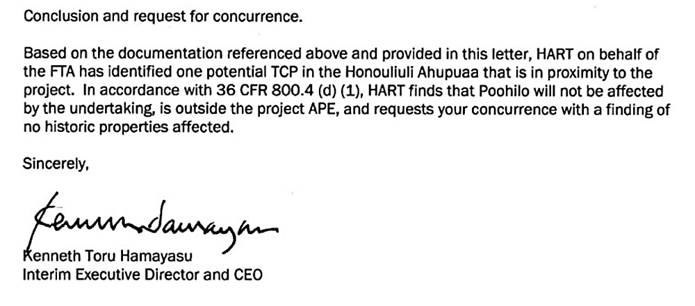
Toru Hamayasu then HART rail interim Executive Director and CEO writes in 2012:
ABOVE: This is the final HART City FTA "concurrence" lie letter that Po'ohilo is "not effected" and "outside of the project APE."
The agreed upon Area of Potential Effect (APE) clearly shows Po'ohilo is within the agreed upon effect area. HART later shows a much smaller rail corridor map claiming Po'ohilo is "outside" but this very misleading map is NOT the agreed upon Area of Potential Effect
(APE.)
This map is NOT the Area of Potential Effect (APE) but instead the actual rail corridor and station footprint of land use. However the Po'ohilo mount is within it anyway and under State and Federal law this would be "an effect on the historic cultural site."
There is a letter from then DLNR chair Laura Thielen that clearly states what the
APE is, and early 2011 HART maps below clearly show Po'ohilo is within the APE.
ABOVE: Early 2011 HART Rail map clearly shows Po'ohilo is in the rail corridor APE
Maps show the location of the Po'ohilo site today and in relation to Honouliuli Village
The FTA, City, etc., all agreed at the time of the Programmatic Agreement this would be the legal process for the HART rail project - but then they later fully reneged and lied.
2011 Rail Programmatic Agreement
"The City shall complete any treatment measures prior to undertaking each construction
phase that would adversely affect a TCP. Regardless of effect determination, the City
will complete NRHP nominations for properties that meet the NRHP criteria for TCPs."
So even with a totally bogus "no effect" determination, Po'ohilo should have had a National Register nomination like the Honouliuli Bridge. FTA, HART City totally reneged on this signed agreement and there has never been any accountability at all.
Views of the Po'ohilo 14th century Oahu battle commemoration site
The rise in the center foreground is the site where losing chief Hilo's head was placed on a stake or pole for everyone to see when this was an ancient trail junction near the Honouliuli and Hoaeae ahupua'a boundries.
Journalist Abraham Fornander wrote:
Punaluu was slain on
the plain which bears his name, the fugitives were pursued as far as Waimano, and
the head of Hilo was cut off and carried in triumph to Honouliuli, and stuck up at a place still called Poo-Hilo. (Fornander
1996:89–90)
https://en.wikipedia.org/wiki/Abraham_Fornander
The National Historic Preservation Act (NHPA) did not come into effect until 1966 which is why the roadways were constructed over the ancient trails without any further historic preservation analysis or documentation. Only by researching old archive accounts, books, records and maps can this very important historic site be finally recognized as where it is.
It is rare to find a native Hawaiian historic site like this that can be specifically located and which goes back to the 14th century! This is a major Oahu battlefield victory commemoration site and there should be a marker, plaque and National Register nomination written and filed as required by the HART rail Programmatic Agreement.
The major opportunity to recognize this important site was thrown away by HART, FTA and SHPD which had the federal funds to do a National Register of Historic Places nomination.
Instead HART throws money at coloring books, comic books and video games as "cultural mitigation" supposedly "required" under the HART rail Programmatic Agreement. This is why HART rail has been such a total fiasco because there has never been any accountability or audits as money is thrown down ratholes and wasteful contracts given to insiders.
It is also likely the native spirits have cursed the whole project for being so corrupt, harmful and disrespectful to native Hawaiian culture and history.
The ancient trail that went around Puuloa (Pearl Harbor) to Waianae later became a
horse and buggy path and then finally the paved two-lane Farrington Highway.
Po'ohilo and Honouliuli
As the largest ahupua‘a on the island of O‘ahu,
Honouliuli includes approximately 12 miles of marine coastline from Keahi Point in the east to Pili o Kahe in
the west at the boundary with Nānākuli. In addition to its marine shoreline, Honouliuli also has
several miles of shoreline along the western margins of Ke-awa-lau-o-Pu‘uloa (Pearl Harbor), the crown
jewel of harbors in all of the Hawaiian Islands. Several loko (fishponds) and fish traps are
located along this Puuloa coastline in Honouliuli, and these waters are famous for their pipi (pearl
oysters,) and a wide variety of fish including deep ocean species (Handy and
Handy 1972:469).
The Po'ohilo site can be easily seen by local car commuters today but never been officially recognized because HART Rail politicians wanted the true story suppressed.
Royal cloak design obtained during the 1824 Royal Navy visit to West Loch
1878 Map shows the ancient trail route that later became Farrington Highway
1881 Map shows the ancient trail route that later became Farrington Highway
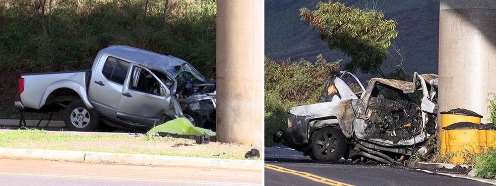
The Po'ohilo Area Is Associated With Fatal Traffic Accidents Including Murder - Suicides
Somewhat ironically the Kahi Mohala psychiatric facility is close by
Most all of the fatal accidents involve high speed and concrete rail pylons
Farrington Highway has a long downhill stretch near the Po'ohilo area that seems to
excite and encourage speeding as well as murder - suicide.
Ironically the upper downhill section has guardrails while the area by Po'ohilo and the psychiatric facility where greatest downhill speed can be obtained has concrete pylons right next to the highway and no guardrails at all allowing for an impulsive murder - suicide swerve decision by the person at the wheel.
HART Rail cars have to make a long climb up to the Po'ohilo site. Some believe
this section could result in a serious future derailment and possible crash into Waipahu
station during a heavy rain. These events happen on other commuter rail lines.
Po'ohilo area has many myths and legends associated with spirit deities, Night Marchers, ghosts and strong mana spirit
In Hawaiian legend, Night marchers (huaka'i pō or "Spirit Ranks," 'oi'o)
are the ghosts of ancient Hawaiian warriors.
It is the Hawaiian experience that
these trails were, and still remain, important features of the cultural landscape.
Even in circumstances where physical remains of the ancient trails have been erased by development and modern
land use, it is believed that the po‘e kahiko (ancient people) still walk the
land—sometimes in huaka‘i po (processions of night marchers)(Luomala 1983; Interview with Thelma
Parish, May 2, 1997, Maly and Maly 2011b:818).
They march in large groups to ancient Hawaiian battles sites or to sacred places. Legend says the night marchers are normal-size warriors, dressed for battle, carrying spears, clubs, and some are beating war drums and blowing tones from conch shells, to announce the advancing of their march. Some may be the Oahu warriors who died defending Ewa and others may be the huge number of slain invading warriors from Maui and Hawaii islands.
Sinkholes appearing near Po'ohilo guideway
There may be a large cavern or subsurface water tunnel under the highway and rail guideway in the Po'ohilo area where the Honouliuli stream runs through.
This may be what is causing the deep sinkholes to appear near the rail pylons.
Hawaiian cultural practitioner Michael Kumukauoha Lee of Ewa, (now deceased,) strongly believed the area had a strong mana (spirit) and that a large shark god cave was located below ground under the Farrington Hwy bridge, which is also near the crash areas. This may just be coincidental. The area is also known for numerous Pueo and Barn owls.
Mike Lee was a widely recognized Kumu and Ewa Honouliuli cultural descendant with family relations to Hawaiian royalty and early immigrant settlers like the Meek family.
Lee believed the cave entrance is from West Loch and a cavern tunnel likely runs beneath the Po'ohilo area. This tunnel was created by the constant water flow over a thousand years from Honouliuli Gulch. However this is not officially documented and the rail construction in that segment was always very secretive and often done at night. Dewatering equipment was always seen along this rail segment and on into Waipahu where subsurface springs and streams were constantly hit by boring equipment with gushing water shutting down construction.
It is a scientific fact that sharks like to lie motionless in karst caves fed by fresh aerated water, as is often seen along the Mexican Baja karst coast area by scuba divers. Many Hawaiian stories about Ewa Puuloa are about shark caves and shark gods. It was a huge karst shark cave that completely destroyed Pearl Harbor Dry Dock 1 in 1913, causing it to collapse, destroying a structure that took two years to construct. This was Pearl Harbor's greatest disaster prior to December 7, 1941.
Destroyed Pearl Harbor Dry Dock 1 in 1913 by shark cave
Kaʻahupahau lived in an underwater cave in Honouliuli lagoon (West Loch.) Kahiʻuka lived in an underwater cave off Mokuʻumeʻume (Ford Island) near Keanapuaʻa Point at the entrance of East Loch.
The Navy began a $3 million Pearl Harbor drydock project in 1909 (at today's costs 2,640.93% higher) - to be the largest in the world - However the contractors had been having trouble with the bed of the drydock. And upon completion it suddenly blew up with a tremendous explosion on February 17, 1913. (Hawaiian Gazette, November 24, 1916)
They cannot say they were not forewarned. “While at work three Hawaiian fishermen come to where we were working, one of whom was aged, who asked me what we were doing there. ‘Digging a hole 50 feet deep’ was the reply. He then told me to move away from there; and when asked why, he said, ‘These places are tabu; they belong to shark god, name Kaʻahupahau.’” They stayed there several hours, then he said to me that, ‘You people will be punished severely.’”
After the expensive dock site disaster was cleared and water pumped out, at the bottom in the middle of the dock was a cave of nine feet diameter. Mr. Hartman, an assistant construction boss, found a backbone of a big shark, 14' 4" long.
Mike Lee has said the Po'ohilo area has an underground shark god cave, strong Mana (spirit) and predicted that it could be a disaster site some day
Lee during visits by KITV news and OHA compliance manager Kai Markell, pointed out how the soil was continuously eroding into sinkholes that went deep underground and that he believed someday a bad car or rail crash might happen along the Farrington highway section or steep downhill segment that goes into Waipahu, especially if raining heavily and wet. These observations were made prior to a later series of bad fatal car crashes into rail pylons which occurred at the same Farrington Highway location near Po'ohilo.
Because of the huge rail construction rush on this West Oahu Farrington Highway (WOFH) section Kiewit had a lot of costly bad concrete pours, cracks, dewatering problems and expensive contract change orders
During rail construction in this area and into Waipahu, it was plagued by bad guideway construction, bad concrete pilings pours, and massive construction site flooding from underground streams. Waipahu means "burst or explode" and "water forced up."
A lot of work in the Ewa section was done in the middle of the night and under great secrecy as a myriad of issues including caves, cave-ins and underground streams flooded bore holes, damaging the liquid concrete castings for rail pylons which all had to be redone.
Hammatt and Shideler 1990
In 1990, CSH completed an archaeological inventory survey
prior to development of the West Loch Bluffs Project in Honouliuli, makai of
Farrington Highway. Five historic archaeological sites were identified (SIHP #s
50-80-12-4344, -4345, -4346, -4347, and -4348) and were recommended eligible to the Hawaii
Register of Historic Places under significance criteria C and D. These five sites consisted
of Ewa Plantation Company remnants, including evidence of irrigation systems, two
pump houses and wells, and additional architectural and industrial features.
Remainder of numerous National Register eligible sites destroyed by D.R. Horton Hoopili contractors. The 1916 date very likely commemorated a southern extension of the massive 1916 Waiahole ditch water system.
http://imagesofoldhawaii.com/waiahole-ditch/
SIHP #50-80-12-4344—Ewa Plantation Infrastructure
Additional features of this archaeological resource were
documented in 2006 during another archaeological inventory survey conducted by CSH,
Inc. (O'Hare 2006a, 2006b). Features of SIHP #50-80-12-4344 are found 200
feet mauka of the Project alignment along Farrington Highway in Honouliuli, and
additional features of SIHP #50-80-12-4344 are 5,500 feet makai of the proposed
alignment. Certain features of the `Ewa Plantation
infrastructure have been determined eligible to the Hawaii Register of Historic
Places under Significance Criteria C and D, but the overall archaeological resource
does not appear on either the State or National Registers (Hammatt 1990a, 1990b;
O'Hare 2006a, 2006b).
SIHP #50-80-12-4344 consists of several features associated with Ewa Plantation infrastructure, including walls for erosion prevention, berms, concrete ditches, pipes, and other structures associated with the Ewa Plantation irrigation system. The archaeological resource was defined during an Archaeological Inventory Survey conducted by CSH (Hammatt 1990a, 1990b). Three features (a sign and various pipes) were found during this survey and assigned SIHP #50-80-12-4344.
Additional investigation was recommended, but these features were destroyed during bulldozing in the area by an unknown source before this investigation took place.

Kipapa Gulch
Fornander suggests it was not considered a war between the two islands, but, rather, it was a raid by some restless and turbulent chiefs. The invading force first landed at Waikīkī and proceeded to ʻEwa and marched inland.
At Waikakalaua (an upland ʻili of Waikele) they met Māʻilikūkahi and his forces, and a bloody battle ensued. The fight continued from there to the Kīpapa gulch – stretching across Kīpapa (an ʻili of Waipiʻo,) Waikakalaua and the place known as Punaluʻu.
Tradition has it that the body count from the invaders was so great that it is said the area was paved (kīpapa "placed prone") with their bodies.
Punaluʻu, an upland ʻili, was named for one of the invading warrior-chiefs killed during the battle. Another warrior-chief, Hilo, was also killed in the battle.
Poʻohilo (an ʻili of Honouliuli) is named from events following a battle in the Kīpapa-Waikakalaua region in which the head of Hilo was placed on a stake at this site and displayed.
Kanupo‘o (an ʻili of Waikele) may be translated as meaning, “planted skull” and seems to imply an event of some importance - it may be tied to events of the battle at Kīpapa and the naming of Po‘ohilo at Honouliuli.
EWA
Today, you don’t necessarily use the words ʻEwa and Kalo in the same sentence – we tend to think of the ʻEwa district as dry and hot, not as a wetland taro production region. Some early written descriptions of the place also note the dry ʻEwa Plains.
However, not only was ʻEwa productive, its taro was memorable.
Ua ʻai i ke kāī-koi o ‘Ewa.
He has eaten the kāī-koi taro of ‘Ewa.
Kāī is O‘ahu‘s best eating taro; one who has eaten it will always like it. Said of a youth or maiden of ‘Ewa, who, like the Kāī taro, is not easily forgotten. (ʻŌlelo Noʻeau, 2770, Pukui)
‘Ewa was known for a special and tasty variety of kalo (taro) called kāī which was native to the district. There were four documented varieties; the kāī ʻulaʻula (red kāī), kāī koi (kāī that pierces), kāī kea or kāī keʻokeʻo (white kāī), and kāī uliuli (dark kāī.) (Handy)
‘Ewa was at one time the political center for O‘ahu chiefs
This was due to its abundant resources that supported the households of the chiefs, particularly the many fishponds around the lochs of Puʻuloa (“long hill,) better known today as Pearl Harbor. (Cultural Surveys) ʻEwa was the second most productive taro cultivation area on Oʻahu, just behind Waikiki. (Laimana)
The salient feature of ‘Ewa, and perhaps its most notable difference, is its spacious coastal plain, surrounding the deep bays (“lochs”) of Pearl Harbor, which are actually the drowned seaward valleys of Ewa’s main streams, Waikele and Waipio.
The lowlands, bisected by ample streams, were ideal terrain for the cultivation of irrigated taro. (Handy, Cultural Surveys)
Place Names in Honouliuli in the Mahele – Po’ohilo Listed Many Times
http://www.hoakaleifoundation.org/documents/place-names-honouliuli-m%C4%81hele
The named localities
extend from the shore to the mountain slopes. In some instances the place names
identify a specific site on the land, while others describe regions or strips
of land such as in the name Honouliuli, which comprises some 43,250 acres.
Other parcels of land identified in the records include ‘ili, kula, mo‘o ‘āina,
lo‘i, or kīhāpai. These parcels of land were established as smaller
subdivisions or management parcels which might include a quarter-acre parcel
for a single house site or garden plot, or which might include thousands of
acres like the ‘ili of Pu‘uloa, which contained 2,610 acres.
http://www.hoakaleifoundation.org/images/m%C4%81hele-award-book-survey-helu-848-kapule
Parcel 1, Mooaina of
Kumuhau, ili of Poohilo. Honouliuli, E. O. Containing 9.34 chains. Parcel 2,
Three loi at Palaau, Poohilo. Containing 6.73 chains. Parcel 3, A loi and house
lot. Containing 6.21 chains. Parcel 4, A loko (fishpond). Poohilo, Honouliuli,
E. O. Containing 2.86 chains. Parcel 5, A kula maia (banana planting
field). Poohilo, Honouliuli, E. O.
Containing 2.36 chains. The combined total of these lands is 2 acres, and 8.02
chains. Source: Māhele Award Book 7:260.
https://www.waihona.com/previewDoc.asp?type=RP&docId=67509
Royal Land Patent No.
3636, Kuahilo, Poohilo Ili, Honouliuli Ahupuaa, District of Ewa, Island of
Oahu, 1.819 Acres, 1857 LCA Number: 01666B
https://www.waihona.com/previewDoc.asp?type=RP&docId=71269
Royal Land Patent No.
7356, Mauwele, Poohilo Ili, Honouliuli Ahupuaa, Ewa District, Island of Oahu;
5.06 kaulahao huinalike (.506 Ac.), 1879
LCA Number: 01666
https://waihona.com/previewDoc.asp?type=RP&docId=69378
Royal Land Patent No.
5483, Kauhailepa, Poohilo Ili, Honouliuli Ahupuaa, District of Ewa, Island of
Oahu, 2 apana, 1 Acre 6.34 Chains (1.634 Acres), 1864 LCA Number: 00911
http://www.hoakaleifoundation.org/images/palapala-sila-nui-helu-3518-kuleana-helu-1570-kekua-1
Honouliuli. 1 acre,
7.24 chains. February 2, 1857. Signed by Kaahumanu and Kamehameha. Volume 15,
p. 293–294.
http://www.hoakaleifoundation.org/documents/helu-1570-claim-kekua-kua
Fraudulent HART Rail “Farmland Conversion Impact Rating” (NRCS-CPA-106)
Five very qualified experts rated the Hoopili lands as exceeding the requirements
of the “Farmland Conversion Impact Rating” (NRCS-CPA-106)
Rail contractor Parsons Brinkerhoff, who never consulted any agriculture experts and never did a farmland site visit, rated the rich chocolate brown Ewa Honouliuli alluvial lands (in their own rail construction profiteering self interest) as BELOW the Section 4f impact rating required to provide for farmland preservation. The score arrived at, and thereafter used officially by the City, HART and FTA to justify not evaluating alternative routes or any mitigation.
The official FTA score on form NRCS-CPA-106 for the Rail project is 120. The threshold triggering required alternative evaluation is 160. Five independent third parties scored the impact rating at an average of 226.
All of this super rich soil, highly productive farmland will all be paved over in asphalt and concrete due to the very corrupt and short sighted Honolulu City government.
Ewa Farmland Conversion Impact Rating
Ewa Plain Major Hawaiian Burial Place - Federal TCP Documents
Honouliuli Village TCP - One of Oahu's Most Important Ancient Communities Still Survives Today
"Shell Game" Honolulu HART Rail Barely Started Already Massive $1 Billion In Debt