Ewa Farm Land Conversion To Commercial Development Unconstitutional
by John Bond Kanehili Cultural Hui
TO: City Council Chair Ernest Martin, Councilmember Ikaika
Anderson
and Honoulu City Council members
Honolulu, Hawaii
Bill 3 Is Likely Unconstitutional; FTA Has
Liabilities In West Oahu HART Rail Segment
Bill 3 is
unconstitutional and counter to the will of the people of Oahu
and
the cultural rights of Hawaiian people.

The Hoopili lands meet every single
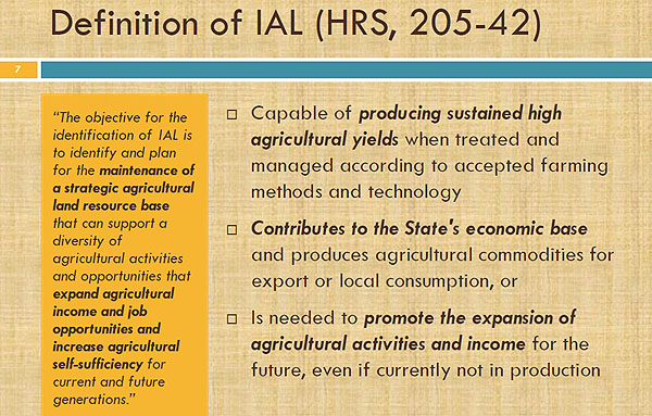
criteria to be a recognized Important Agricultural Land (IAL) under the State of
Hawaii Constitution. In ALL of the substantial amount of documentation I have
assembled there is nothing in State law, as frequently asserted by City Department of Planning and Permitting (DPP),
that prevents its mapping as Important Agricultural Lands.
The
identification and designation of Important Agricultural Lands (IAL) was first
proposed at the 1978 Constitutional Convention and subsequently approved by
voters in the same year. Enacted as
Article XI, Section 3, of the Constitution of the State of Hawaii, the State is
required to conserve and protect agricultural lands, promote diversified
agriculture, increase agricultural self-sufficiency and assure the availability
of agriculturally suitable lands.
This Bill
3 will surely be the city bill that shall live in infamy. The politicians that vote
for it will be remembered for decades as committing one of the worst
environmental disasters ever.
The City DPP is staging
three public hearings on the Oahu Important Agricultural Lands Mapping Projectwhich will be a PR attempt to explain why they are acting in behalf of land
commercial developers rather than the Hawaii State Constitution Article XI, Section 3
Be it resolved by the Council of the
City and County of Honolulu that the City’s Agricultural Liaison is urged to
expedite the identification and mapping of important agricultural lands and
ensure that the IAL maps support and protect farming by stabilizing the
agriculture land
base.
City Council Reso and Agricultural Liaison Show Intent- But Thwarted By DPP:
Hoopili
would have been mapped had the mapping taken place in 1978 or in 2012 when the
City Council passed CCR 12-23, CD-1, FD-1, or when Laura Thielen issued her
City Ag Liaison Report which clearly stated the process and the mandate to
follow the Hawaii State Constitution.
The City
DPP is holding the three meetings on IAL and already says in their announcement
that “Hoopili and Koa Ridge developments can NOT be designated as IAL because “State law does not allow land identified
for urban use by the State or county to be designated as IAL.”
That
these lands should have been mapped since 1978 except there was "no
money" (as was the continuous excuse for years)- the intent of Hawaii
State Constitution Article XI, Section 3 never the less still trumps ALL and says SHALL MAP
Important Ag Lands. No State or City boundary or “plan” can subvert and pervert
the intent of the Hawaii State Constitution and public interest.
Bill 3 and City DPP are actually running an
unconstitutional land development scheme. This land was supposed to be mapped! If not, WHY do we have a State Constitution?
As stated in Chapter 205, Hawaii Revised Statutes,
(State) and county incentive programs shall provide preference to important
agricultural lands and agricultural businesses on IAL.
There shall be
an inclusive process for public involvement in the identification of potential
lands and the development of maps of lands to be recommended as IAL, including a
series of public meetings throughout the identification and mapping process.
What City DPP is really doing is holding a FAÇADE of
public meetings in which they have dictatorially PRE DETERMINED the “inclusive process for public involvement in
the identification of potential lands and the development of maps of lands to
be recommended as IAL” as stated in Chapter 205, HRS.
HART Rail Converts And Destroys Farmland For Land Development
And here is WHY City
DPP is running this fraudulent land conversion scheme:
Section 4 (f) Federal Transportation
Projects: Farmland Protection Act:
Minimize
impacts on farmland and maximize compatibility with state and local farmland
programs and policies. All projects that take right-of-way in farmland, as
defined by the regulation.
Farmland Protection Policy Act of 1981: 7 U.S.C. 4201-4209
1.
Early coordination with the NRCS.
2. Land evaluation and site assessment.
3. Determination of whether or not to proceed with
farmland conversion, based on severity of impacts and other environmental
considerations.
The City
is running this unconstitutional ag land conversion scheme in an attempt to
absolve the Federal Transit Administration in being legally responsible for funding
the destruction of Important Ag Lands as identified in the US Natural Resource
Conservation Service Farmland Impact Conversion Rating Form AD 1006.
Previously
we have learned that HART Rail contractor Parsons Brinkerhoff graded West Oahu
Ewa Plain rail right of way lands, in US Natural Resource Conservation Service
Farmland Impact Conversion Rating Form (NRCS-CPA-106), as being SUB PAR and LOW
AG VALUE, while five agricultural experts rated the same lands using
NRCS-CPA-106 as nearly twice as high and meeting the Important Ag Land
standard.
So really, this
whole City DPP ag land devaluation process is a compounding of fraud upon fraud
to meet land developer and Transit Oriented Development interests. Who needs a
State Constitution when you can become a third world special interest
dictatorship?
Government Data, Maps All Shows Ho’opili Is
An Important Agricultural Land
The State
of Hawaii for many decades in the Oahu General Plan identified Ewa Plantation
and Ho’opili as Agricultural Land and why to this very day the land is
classified as “AG-1.”
The State
of Hawaii ALISH map shows the Ho’opili area as PRIME AG (Agricultural Lands of
Importance to the State of Hawaii – ALISH)
The State
of Hawaii Land Study Bureau (LSB) map shows Ho’opili as
top rated soils A &
B.
The Ewa Plain Farmlands Are Also Wetlands For Migratory And Endangered Species
Laura
Thielen in 2012 was hired by the City to map IAL and said it was
"easy" to map the lands and could be done within a year. Her report
laid out the process. But it wasn’t done!
Just because an Urban Growth Boundary has been
administratively created by the City or State does NOT CHANGE what can be
mapped as Important Agricultural Lands or the intent of the Hawaii State
Constitution, Article XI, Section 3.
Honolulu
City Council Reso 12-23 states "lands to
be mapped
even if in an Urban Boundary."
The City DPP had even testified
during the committee hearing that Urban
Growth Boundaries can be modified if IAL are identified.
The intent of the
Hawaii State Constitution supersedes ALL administrative boundaries.
Now City DPP is told to intentionally
mislead the public in their IAL meetings where major IAL decisions of interest
to the community are already made and pre-determined!
Nothing in Chapters 205 or Act 183 says
State Law "Prevents" IAL Mapping of Hoopili.
Ho’opili totally qualifies under ALL
criteria as IAL.
35-40% of local produce comes from Ho’opili.
All past stated political and legislative goals
and agendas have been for “greater agricultural self-sufficiency and less
dependence on imported foods.”
The DPP
is acting completely in behalf of major land development, against the will and expressed
intent the people of Hawaii, creating an environmental disaster, endangering
the population of West Oahu and going against the Hawaii State Constitution Article
XI, Section 3 and 1978 Hawaii Constitutional Convention.
Bill 3 Is Anti Food Security And Creates An
Environmental Disaster Condition
Ho’opili
will create a SOCIAL INJUSTICE - ENVIRONMENTAL DISASTER for H-1 Commuters and
is NOT “Smart Growth” Transit Oriented Development.
A quote from State of
Hawaii DOT director Brennon Morioka from 2009: "Even
under a best case scenario, which includes an optimistic rail transit
operation, the H-1 freeway would operate at LOS E with the Ho`opili project. At
LOS F, there is gridlock on the freeway." (LOS -
level of service.)
Hawaii imports
roughly 90% of our food and we have less than
two week’s supply of food in the
islands.
We need to be aware of the many things that could cut off our food
supply such as a tsunami or hurricane which could destroy our ports and coastal
airports. Oahu is long, long overdue for such a major disaster based upon
historic records. A major earthquake in California, Washington or Alaska could
destroy West Coast ports and roadways and a world pandemic could close the
islands to all flights and shipping. These are all very REAL historic
possibilities.
Oahu is being over built beyond its sustainability
and most
people know this.
Surely
the time will come when these Ho’opili lands will be needed for food in order
to survive. But they will be gone forever covered in concrete and asphalt. Most
people on Oahu intuitively feel this is unmitigated greed and insanity- as well
as unconstitutional!
Important
NEW cultural and historic information overlooked by the HART EIS has been
brought to the attention of HART and FTA from Kanehili Cultural Hui of Ewa
Honouliuli, including four NEW Traditional
Cultural Properties of significant magnitude and impact on the West Oahu
HART Rail segment.
Wide Spread Public
Opposition To Bill 3 And Decimation Of Important Ag Lands
Ho’opili is actually a
fake development name for the historic Honouliuli
agricultural Ewa Plain

Star-Advertiser Poll March 29, 2015 showed
overwhelming massive public support for preserving IAL with 93%, 1,099 votes, to
preserve prime, A-B farmland from development.
The CEO of Office of Hawaiian Affairs (OHA) has
expressed in numerous written testimonies that OHA has great reservations about
the Ho’opili lands being taken out of agricultural production.
These same lands
were used for 1000 years as native Hawaiian agricultural lands where
Oahu’s largest pre-contact native Hawaiian community thrived on the rich
volcanic soils with many natural springs that formed the Konohiki managed
ahupua’a food ecosystem.
A
Honouliuli lineal native descendant has provided this
very important cultural
history:
Ewa was the central governance extending throughout the
archipelago and later after the 6th millennium was associated with the
Hema-Ohua lineage. From Ohua extended
Maweke lineage that provided the foundation for all the millennial kings
throughout the archipelago.
Ewa was not only where centralized rule is associated in
the most ancient times, but also, the central breadbasket.
That is why less royal gravesites are found
there, because of its being a food, gathering area. Also, it is a most valued area for
propagating and gathering sacred plants and minerals by the kahuna lapa'au.
Judith
Flanders, a descendant of James Campbell and a beneficiary of the Campbell
Estate, said in a news article that estate trustees made a mistake selling the
lands under Ho‘opili to Horton.
Flanders urged the city to rectify "the wrong that was perpetuated against
the aina when the Campbell Estate sold somewhere around 1,375 acres of prime
grade A and B agricultural lands to the developer."
Testimony
typically runs about 4-to-1 against approving the Ho’opili agricultural land
development plan during public hearings. No one is opposed to creating jobs,
however there are already very large home tracts planned on non-farm lands ready for construction.
Nearby Kapolei, the “second city,” still has many large undeveloped open city
blocks that are urban zoned and far better suited for concentrated “Smart
Growth” development rather than the vast sprawling Ho’opili H-1 traffic
generating housing tract that is the complete antithesis of “Smart Growth.”
Highly Productive Soils And Conditions Can’t
Be Replaced Someplace Else
The Ewa
Plain lands cannot be easily “replaced” as developers like to state. These historic
and culturally important spring fed rich volcanic agricultural lands CANNOT be
administratively moved like furniture to another location.
We can’t do this
with historic and Traditional Cultural
Property sites either, which this area is- a TCP- a Traditional Agri-culture Property.
Hawaii
has many very UNIQUE Micro-Climates.
Because of the unique local combination of
solar radiation, volcanic A & B soil and mountain spring water these lands
can produce four ag farm crops a year.
This is an important production capacity
that can’t be matched by “replacement” land anywhere else on the island. The
Ho’opili land has very favorable conditions for crop production, high-quality
soils, flat or gently sloping terrain, high solar radiation (sunshine) with low
pumping costs for irrigation. All farm conditions on this land are ideal.
The largest, most productive and profitable sugar
plantation in the Hawaiian Islands was the Ewa Plantation on these very same
lands.
All historic and cultural evidence shows these as Important Agricultural
Lands. The Ho’opili area constitutes about one-fourth of what was called the
Golden Triangle and is the only part of the Golden Triangle still remaining in
agriculture.
“For
vegetable crops, the Ho’opili lands are among the most sustainably productive farm
lands in the world,” says Hawaii ag expert James Brewbaker. “Yields of crops like sweet corn are at least
55% higher there than on the North Shore slopes. Ho’opili land produces more
than 40% of Oahu’s fresh broccoli, beans, romaine lettuce, and zucchini, and
more than 70% of Oahu’s fresh corn, cantaloupe, pumpkin, and honeydew, along
with a number of other popular local crops. (See our photos of local farmers
and local families using this ag TCP.)
Ho’opili’s
1,497 acres constitutes a huge chunk of ag land on O’ahu- 32% of Oahu’s active
farm acreage. Hawaii Soil expert Jonathan Deenik has testified, “Close to 90%
of the Ho’opili area is composed of high activity clays, which are
characterized by very high nutrient retention capacity, and high fertility. “
Because
these acres are clay, which contracts and expands the Ho’opili developers and
HART rail stations will need to scrape off three or four feet of the prime, A
and B quality soil, haul it away, and replace it with three feet of coral. This
destruction of the Golden Triangle farmland will be total, irreversible and
impossible to restore for as long as humans live on Oahu.
The Ewa
Plain farmland is well-located for farmers due to the short trucking distance
to Kapolei food distributors, Ko Olina Resorts and downtown Honolulu markets
via H-1. The lands have a completely TURN KEY ag infrastructure- a large scale
Ewa Plantation water distribution system, conveniently accessible field plots,
close by public roadways and electrical power.
There are NO replacement areas
for these ideal Ewa Plain farm lands. Demand for locally grown foods is
skyrocketing and these farm lands could actually become a tourist attraction.
The annual October Pumpkin Patch is a very popular local Ewa farm land tradition.
Important Historic
and Cultural Aspects Of Ewa Plain Lands Under FTA Review
Currently
the Federal Transit Administration has been notified by the HART Programmatic
Agreement manager that the entire Ewa Plain –HART Rail Area of Potential Effect
(APE) has four identified and unmitigated Traditional
Cultural Properties (TCP’s) including the 1000 year old Honouliuli Ewa Plain
agricultural lands that were the Oahu food breadbasket in the Hawaiian
pre-contact era.
Another
large looming problem is that for approximately 1000 years native Hawaiians
lived on this same land raising food and families- and died and were buried on this same land.
Native burial sites are
sacred and there are likely tens to hundreds of thousands of native Hawaiian
iwi burials on this Traditional Cultural
Property that will be disturbed and dug up.
Other Outstanding
Legal Issues Not Settled
A lawsuit
by the environmental group Sierra Club and former state Sen. Clayton Hee argues that
the state has a constitutional obligation to protect important agricultural
land.
The case is pending before the state Supreme Court. The outcome of the
case could have a major impact on many land development plans in this Ewa Plain
area and Bill 3 should have been DEFFERED.
Widespread Public Opposition – There is
Nothing SMART About Bill 3…
The Kapolei
“Second City” has vast EMPTY blocks of land while DPP wants MASSIVE URBAN SPAWL
on IAL Farm Land- This makes absolutely NO SENSE.
The H-1 traffic is already
rated as INSANE and this project will make H-1 a total parking lot and a very
dangerous future public disaster when a major emergency strikes. The project is
missing approval from the Navy to allow storm water from the development to
intersect Navy-owned land and flow into West Loch, Pearl Harbor. Any planned
“holding pond” will allow contaminated water to seep through the porous ancient
coral reef karst in a matter of days.
There has been a mushrooming of public consciousness
a
bout fresh fruits and vegetables.
People are concerned about nutrition and many want organically or
locally grown food. They feel strongly
about food security and the need to save important local traditional farmlands.
Residents are willing to pay more for healthy, locally grown food and create
more opportunities for local farmers.
The
Kapolei NB passed a resolution opposing the Ho’opili. Makakilo-Kapolei-Honokai Hale Neighborhood
Board stated its strong opposition to the Ho'opili development.
Kanehili
Cultural Hui has assembled a large on-line collection of maps, documents,
photos about the Ewa Honouliuli (Ho’opili)
- former Ewa Plantation farmland that shows it is not only very valuable farmland
but also a Traditional Cultural Property which can become a Federally
recognized property placed on the NPS National Register in Washington, DC.
We have
also gone through the quite massive Hoopili EIS and related Ewa plantation
cultural history documents that help make the Traditional Cultural Property (TCP) case. TCP
identification is somewhat like a public referendum- the public can
decide what farmland is a Traditional
Cultural Property. People don't have to be a native Hawaiian or a
farmer to believe a TCP is an important cultural place in the community.
While Ewa
Plantation Villages still exist and are on the State historic register, the actual Ewa
agricultural fields, which also still exist in original plantation
plots- are still in ag production as part of a 1000 year old cultural practice.
Whether it is native Taro, sugarcane fields or supermarket table veggies, the ag culture lives on and THAT
is the TCP that still exists today!
Kanehili
Cultural Hui, a 501-c-3 has a mission statement to work for the identification
and preservation of historic and cultural areas, both Western and native
Hawaiian in the ahupua’a of Honouliuli. Ho’opili
is sited on very historic kalo lands that go back 1000 years with an 1825
documented trail network (Malden Map).
The primary waterway through the area is
Ka Lo’i (kalo fields) gulch which is today a channelized waterway that
originally fed these many fields. The largest pre-contact native population on
Oahu lived at Honouliuli (Hoopili).
All of these historic facts show the area
was a Traditional Cultural Property
(TCP) as found in Federal documents (Navy, HART) which have been left out of
the previous Land Use Commission reviews.
Shared Drive Collection of Maps, Documents and Photos Supporting This Letter
City Bill 3 Violates Hawaii Constitution, Creates Highway To Hell Death Trap
Ewa Farmland Conversion Impact Rating
West Oahu Eco-Disaster: HART Rail Hitting Karst Water, Sea Caves And Polluting Ewa-Honoululi-Waipahu Wetlands
West Oahu's greatest natural apocalypse is unfolding, with hundreds
of 8 foot in diameter, 200 foot deep drill bores, the ancient karst water, sea caves and
wetlands are being fractured and polluted, then to be followed by
a major new asphalt and concrete city based around
three huge HART Rail Transit Oriented Developments.
The already fragile Ewa Plain ecosystem based on natural clean water will be destroyed.
HART Rail Ewa Plain Route Drills Into Major 1000 Year Old Native Hawaiian Burial Grounds
By John Bond, Kanehili Cultural Hui
The Great Honouliuli Ewa Apocalypse Returns
Photos Of West Oahu Community Opposition At HART Rail Hoopili Station Meeting In Kapolei
Photos Of West Oahu Community Protests Of Hoopili Project Destroying 1500 Acres Of Prime Historic Ewa Farmland
Photos Of Protest Of Day Of Infamy City Bill 3 Which Destroys 1500 Acres Of Historic Prime Ewa Farmland