West Oahu Eco-Disaster: HART Rail Hitting Karst Water, Sea Caves And Polluting Ewa-Honoululi-Waipahu Wetlands
West Oahu's greatest natural apocalypse is unfolding, with hundreds
of 8 foot in diameter, 200 foot deep drill bores, the ancient karst water, sea caves and
wetlands are being fractured and polluted, then to be followed by
a major new asphalt and concrete city based around
three huge HART Rail Transit Oriented Developments.
The already fragile Ewa Plain ecosystem based on natural clean water will be destroyed.
By John Bond Kanehili Cultural Hui
In Hawaiian, Waipahu is derived from wai, meaning water, and pahū, meaning "burst or explode"; combined, Waipahu means "water forced up as out of a spring."
Above, Pearl Harbor as it was painted in 1898. Pearl Harbor is a vast estuary of ancient coral reef coastal habitats which native Hawaiians made extensive use of.
Estuaries harbor unique plant and animal communities because their waters are brackish—a mixture of fresh water draining from the land and salty seawater.
Pearl Harbor was originally an extensive shallow ancient coral reef embayment called Wai Momi meaning “Waters of Pearl” or Puʻuloa meaning “long hill” by Hawaiians. The large uplands of inland Oahu fed massive amounts of surface and subsurface fresh nutrient rich water into the Pearl River which spawned great quantities of pearl laden oysters and teeming sea life.
Fresh spring water is especially important in the propagation of plant and sea life and the food chains they create- from limu on up to large pelagic fish.
Surface and ground waters are very susceptible to contamination from pollutants.
Contaminants can reach ground water quickly through fractured rock formations or sinkholes in karst areas, such as that found in Ewa. Ground water is more sensitive to contamination in these areas because
runoff may pass directly into the subsurface with little if any infiltration through the soil, a process that typically filters at least some pollutants.
The health of the reef and wetlands directly sustains Oahu's marine life.
Native Hawaiian cultural practitioner Mike Lee holds the canary in the coal mine...
The Ewa Karst is the largest of several karsts on Oahu, but possibly the least studied (in the Hawaiian Islands and especially the United States.) Many State and even some Federal agencies refused to recognize that Ewa has a karst subsurface water system. Most people in Hawaii have never heard of karst or that a large number of the population live on an ancient coral reef.
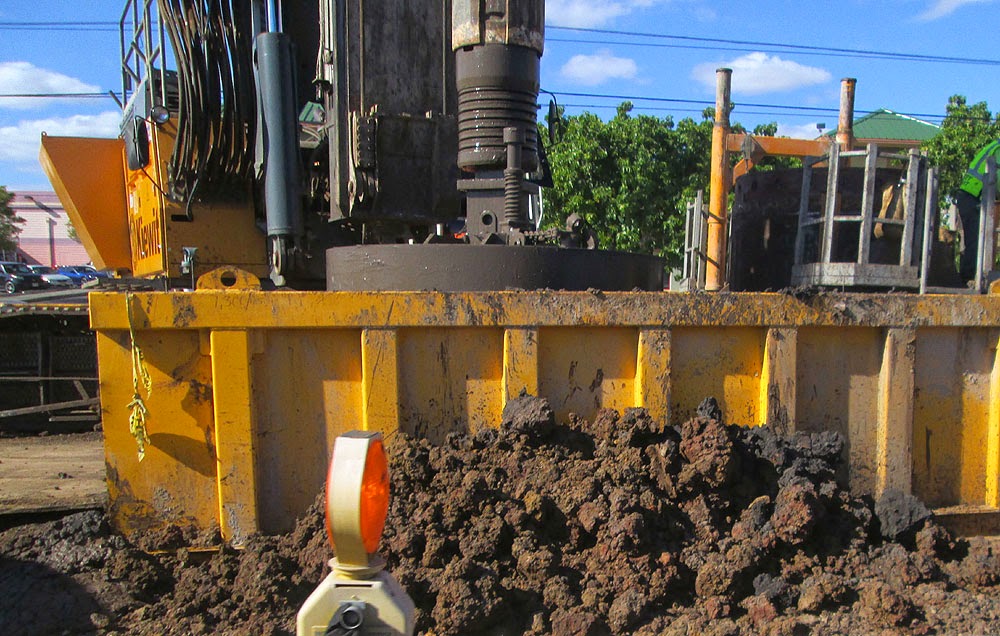
Drilling hundreds of 8 foot in diameter 150-200 foot deep bores are almost certain to contaminate subsurface waters and exposed them to modern street and machinery pollutants.
******************************************************************
Large numbers of endangered local and migratory birds live, nest and feed in these waters
around Waipahu, West Loch and up into the farmlands of Honouliuli.
HART Rail is drilling large numbers of 150 to 200 foot deep, eight foot in diameter holes into ancient karst reef and below surface Pearl Harbor waters greatly endangering an entire ecosystem.
The eight foot in diameter Waipahu deep boring rail column sites have been a consistent
problem for Kiewit because they are hitting large amounts of underground water channels.
The entire ancient history and plantation era history is loaded with springs popping out of the ground everywhere. For agriculture and fish ponds these were ideal conditions. Today everything is being covered in concrete and asphalt with deep boring shafts and concrete down as deep as 200 feet.
This bore is coming up with very dark dripping mud due to hitting large underground
layers of Honouliuli West Loch wetlands.
 Heel to top of head the Statue of Liberty stands at 111 feet. HART Rail pylons
go down to 200 feet deep in an 8 foot diameters, HUNDREDS of these are going in
forever destroying ancient lava tubes, karst waterways and the sacred
wahi pana cave sites of native Hawaiians.
Heel to top of head the Statue of Liberty stands at 111 feet. HART Rail pylons
go down to 200 feet deep in an 8 foot diameters, HUNDREDS of these are going in
forever destroying ancient lava tubes, karst waterways and the sacred
wahi pana cave sites of native Hawaiians.
As seen from West Loch shoreline park, the Waipahu WOFH HART Kiewit machines
are drilling directly down into the waters of West Loch and what was the
ancient Pearl River (Wai Momi).

At the West Loch Shoreline Park the ancient coral reef is clearly visible
“There is a tidal signal (pulse wave) that travels in underground about a mile and a half
twice a day due to tidal change. The karst is very permeable and very transmissive”
- Honolulu City 2007 commissioned Ewa Karst water study - published in Switzerland
******************************************************
Rare and Endangered Native and Migratory Birds use the West Loch and
Honouliuli wetlands around the HART Rail Project for feeding and nesting
On the former Ewa Plantation fields and certainly during pre-contact native Hawaiian times
these wild birds have used the many small former taro fields and plantation catch basins,
as theyhave for thousands of years, for feeding and nesting activities.
State and Federal laws
are supposed to protect these wild birds but they are increasingly being displaced by large
numbers of new houses and soon by massive asphalt and concrete
HART Rail sponsored
Transit Oriented Developments.
The elevated and 24/7 lighted rail stations with 4 AM to 12 Midnight operations are
certain to greatly damage these wild bird habitat with massive amounts of bright project
lighting, loud sounds and hard surface runoff water pollution.
********************************************************
Diamond Head was called such because early Western arrivals found a sparkly mineral they thought were diamonds. Actually it was a white quartz (quartzite ) and calcite. Most karst cave sites today on Oahu are routinely destroyed by construction. The Honolulu City Council flatly refused in 2012 the hearing of a resolution asking that Oahu karst cave sites be evaluated for educational and scientific value. Rarely has such a resolution been so completely cut off.
Big developer lobbyists ordered council members to quickly kill it.
(And this was only a RESOLUTION, not a BILL, see the video record).
Here is why big land developers wanted karst awareness KILLED:
Karst Systems Covered Under US Clean Water Act
"An unbroken surface or shallow sub-surface hydrologic connection to
jurisdictional waters may be established by a physical feature or
discrete conveyance that supports periodic flow between the wetland
and a jurisdictional water. Water does not have to be continuously
present in this hydrologic connection and the flow between the wetland
and the jurisdictional water may move in either or both directions.
The hydrologic connection need not itself be a water of the U.S. A
shallow subsurface hydrologic connection is lateral water flow through
a shallow subsurface layer, such as may be found in steeply sloping
forested areas with shallow soils, soils with a restrictive horizon,
or in karst systems."
A major karst cave site in Ewa in the 1970's was being destroyed by workers when the opening grew so large work finally had to be stopped and archaeologists were called in. After a fairly quick examination and some photos
it was destroyed. Pre-Western contact Oahu has many, many native Hawaiian stories of very large sea caves and coral water channels. Schools of mullet were well known to pass under Oahu from places such as Hawaii Kai to Kailua's Enchanted Lakes via underground lava tubes connected to karst cave entrance portals.
This is considered very dangerous ancient knowledge of Oahu that must be SUPPRESSED.
On Oahu karst channels and sea caves start out as ancient lava tubes fed by entombed fresh water which pours out to the ancient coral reef over thousands of years, eating channels and large caves, depending upon the volume of water over time. Such giant, long lava tubes are well known on the Big Island which isn't old enough to have an ancient coral reef.
 Drilling additional 150-200 deep bore holes nearby when initial holes collapse
greatly contaminates and pollutes the natural karst and underground water system.
Drilling additional 150-200 deep bore holes nearby when initial holes collapse
greatly contaminates and pollutes the natural karst and underground water system.
Construction workers on Oahu are always directed to fill in found caves with dirt, rock, grout and in some very large cave sites such as downtown Honolulu, with liquid concrete. The construction of the First Hawaiian Bank in downtown Honolulu decades ago required massive volumes of concrete in an attempt to fill in a huge underground "void" (cave) which channeled underground water from Nuuanu Valley to off shore via a major sea cave.
Large concrete columns have been known to completely
disappear while being pile driven.
One large Pearl Harbor construction project completely collapsed because it was built over an ancient karst reef. Most of Pearl Harbor and downtown Honolulu are built over ancient karst reefs which were filled over with sand, mud and various land fill materials.
Only ONE University of Hawaii research project has ever attempted to publicly document Honolulu's subsurface caves, waterways and spring sites.
**********************************************************
HART Rail Ewa Plain Route Drills Into Major 1000 Year Old Native Hawaiian Burial Grounds
http://honouliuli.blogspot.com/2015/01/HART-rail-drills-into-burials.html
Nearly all archaeological reports state that Hawaiian sites aren't found in former sugarcane lands and the good reason for that in Ewa is that they were covered over in up slope dirt. Any substantial up right structures were reused. However the features at ground level and below are still there.
Thousands of karst caves, sinkholes, habitation, burial and ancient trails lined with coral slabs lie just below the surface and can be opened up byeither long term weathering or new construction activity.
Drilling huge, deep eight foot diameter holes are most certainly hitting native Hawaiian sites.
*******************************************************
The Ewa Plain covers the southwestern corner of the island of Oahu, Hawaii. The coastal portion of the Ewa Plain is overlain by reef limestone material deposited during numerous past high stands of sea level. The uppermost limestone layer is called the Upper Limestone Aquifer (ULA).
Deep karst waterway channels flow underground through the entire Ewa Plain route
and sites of three transit oriented development rail stations.
Mike Lee: Mountain water and rain fall streams flow directly through the Ewa Plain ancient
coral reef and into the shore and reef system, affecting the health and pollution of these traditional native Hawaiian resources which are also the basis for Oahu's marine ecosystem.
Clean Water Act jurisdiction is over wetlands
adjacent to another water of the U.S. where such wetlands have a
significant nexus with downstream traditional navigable or interstate
waters. Adjacent wetlands will be considered to have a significant
nexus if they, alone or in combination with similarly situated
wetlands, have an effect on the chemical, physical, or biological
integrity of traditional navigable waters or interstate waters that is
more than “speculative or insubstantial.”
As a general matter, “similarly situated” adjacent wetlands include all
adjacent wetlands located in the region. Wetlands adjacent to traditional
navigable waters or interstate waters are per se jurisdictional and do not
require a showing of significant nexus.
******************************************************************
KARST: What Is It and WHY Is It Called That?
Karst is actually very wide spread all over North and South America as well as worldwide.
Karst is actually one of the most important natural systems on the planet. Native Hawaiian culture made very great use of karst terrain and the ecosystems it created in the islands.
The international community has settled on karst, the
German name for Kras, a region in Slovenia partially extending into Italy,
where it is called "Carso" and where the first scientific research of
a karst topography was made.
Karst landforms are generally the result of mildly acidic
water acting on weakly soluble bedrock such as limestone or dolostone. The
mildly acidic water begins to dissolve the surface along fractures or bedding
planes in the limestone bedrock. Over time, these fractures enlarge as the
bedrock continues to dissolve. Openings in the rock increase in size, and an
underground drainage system begins to develop, allowing more water to pass
through the area, and accelerating the formation of underground karst features.
The carbonic acid that causes these features is formed as
rain passes through the atmosphere picking up CO2, which dissolves in the
water. Once the rain reaches the ground, it may pass through soil that can
provide much more CO2 to form a weak carbonic acid solution, which dissolves
calcium carbonate.
******************************************************************
Lands being developed on former Ewa Plantation
farm land for rail exhibit underground karst
This cross section was available in a gulch near the rail Project and shows karst
approximately three feet below a natural alluvial layer.
A location near Barbers Point where the surface karst layer was cut like a knife using a large powerful quarry saw shows a cross section of ancient life that may have included human or
ancient bird bones, ancient seeds long extinct and other important pre-history clues.
*************************************************************
FINAL REPORT – MAY 2007 CENTRAL OAHU WATERSHED STUDY
Prepared For:
Honolulu Board of Water Supply U.S. Army Corps of Engineers
City and County of Honolulu Department of Environmental Services
Prepared By: Oceanit Townscape, Inc Eugene Dashiell 2007
Page 68
An interesting ecosystem to note within the Ewa Plain is a network of karsts (pit caves, or sinkholes). They could also be termed phreatic caves, which develop below the water table.
There are approximately 12,000 acres of exposed reef from Kahe Point to Puuloa, preserving the remains of ancient plants and animals, particularly shells, extinct birds, and two bats, of which one is new to science. 58
The U.S. Geological Survey Ewa Quadrangle shows numerous sinking streams and closed depressions within the karst, some man made.
Some remaining sinkholes of the Ewa Karst are home for öpae ula (Halocaridina rubra), tiny brackish water shrimp. Two to three artificial ponds were dug by the Division of Aquatic Resources (DAR), two of which filled back up with water.
FIGURE 2-11 EWA KARST
Modified by Townscape, Inc.
2.9.5.9 Karst Protection
In 2001, the Estate of James Campbell erected a substantial chain-link fence to protect eight acres of karst with at least 100 sinkholes from destruction by nearby quarry operations. Some other areas, “B6-137” and “B6-22” have been fenced due to efforts by former Bishop Museum vertebrate zoologist Alan Zeigler.
The general ground water gradient
is toward the coast. However, at Honouliuli ground-water
discharges as springs into West Loch.
Therefore, near the coast the brackish ground water floats
on saline water as a Ghyben-Herzberg lens
When the first Ewa artesian well was drilled near Honouliuli in 1879
ground water rose to an estimated height of 32 feet msl (Cox, 1981, p. 55).
Receiving surface and ground waters are both susceptible to contamination from these pollutants.
Contaminants can reach ground water quickly through fractured rock formations or sinkholes in karst areas, such as that found in Ewa. Ground water is more sensitive to contamination in these areas because runoff may pass directly into the subsurface with little if any infiltration through the soil, a process that typically filters at least some pollutants.
The “Possible Northern Extension” of the Ewa Karst is where the Ewa Plantation intentionally used water sluices (which is well documented) to wash hillside soils down to cover the Karst. In many areas on the former Ewa Plantation the alluvial soil is only a few feet deep.

Map of Ewa Karst, base geology by Stearns and
Vaksvik, 1935 modified by unpublished data of Board of Water Supply, courtesy
Chester Lao. Cartography by Carlene Allred.
The HART Area of Potential Effect (APE) both shows areas in fact it completely IGNORED
within the West Oahu APE as well as not even showing in the Waipahu APE the huge effect that hundreds of eight foot in diameter, 150 to 200 foot deep bores will have on the subsurface
ground water and West Loch estuary bird and sea life ecosystems.
Stalactites and
stalagmites in destroyed in Ewa cave B6-139. August 1977. Photos by
J.K. Obota, courtesy
Alan Ziegler. Cave site featured a large fresh water pool.
The Ewa Karst is the largest on the island of Oahu
William R. Halliday The Cave Conservationist February 1998
It covers at least 50 km2 in the southwest corner of the island of Oahu. It is a
semitropical
littoral karst formed on porous, permeable algal and coralline
reef deposits formed during
at least three high stands of sea level.
From present sea level these formations rise to an
altitude of about 20 m. Tidal fluctuations
extend inland from the shore line
but freshwater at least 10 m deep has been found within 2 km
of the shore,
floating on salt water in the form of a Ghyben-Herzberg lens.
The U.S. Geological Survey Ewa Quadrangle shows numerous sinking streams and
closed depressions within the Ewa Karst.
Despite its impressive extent and archaeological and palaeontological values,
the Ewa Karst is almost entirely unknown to karstographers and speleologists.
In 1955, the late Harold S. Palmer (Professor of Geology at the University of
Hawaii) told
me he had seen a meter-long stalactite said to have come from a
cave in the Ewa Karst
************************************************************
FTA-HART Mitigation For 1000 Year Old
"Golden Triangle" Farmland IGNORED
The FTA funded HART Rail project and its massive displacement of ancient spring fed
grade A-B rated farmlands used for 1000 years- by native Hawaiians, the Ewa Plantation and then by produce farmers such as Aloun Farms, was supposed to receive FTA mitigation under the Farmland Protection Policy Act of 1981: 7 U.S.C. 4201-4209
FTA and HART completely ignored and neglected to seriously consider this other
Environmental legislation affecting major federal transportation projects.
In addition Dr. Kioni Dudley a well known farmlands researcher and activist has stated that
he believes that the “Farmland Conversion Impact Rating” (NRCS-CPA-106) which is a
fundamental requirement for all major transportation corridor projects which impact prime
or unique agricultural land was basically "faked."
Under section 1541 (b) of the Farmland Protection Policy Act, 7 USC 4202 (b), Federal agencies must formally assess all Federal projects which impact agriculture. The “Farmland Conversion Impact Rating” is required for this purpose. If the Farmland Conversion Impact Rating exceeds
the regulatory threshold of 160 points, alternatives, in this case alternative routes, that avoid
farmland impacts must be evaluated.
The Farmland Conversion Impact Rating which was done for the Honolulu High Capacity
Transit Corridor (the Rail) is discussed in the “Geology, Soils, Farmlands, and Natural
Hazards Technical Report” dated October 16, 2008, which was prepared to support the
Draft Environmental Impact Statement of the Honolulu High Capacity Transit Corridor.
*******************************************************************
A rare look inside a stalactite rich karst cave with sparkly white Calcite
Calcite laden Oahu karst cave subsequently covered over forever by a land fill.
Pearl Harbor Shark Caves, Shark Gods and Goddesses
**************************************************************
The Large Ewa Karst Cave Destroyed By Developers
After A Quick Archaeology Look
A sizeable phreatic dissolution cave accidentally
opened in 1973 during quarrying
operations ("Site B6-139") was an ''unmodified wet sink-cave". Quarry operators deliberately
tried to fill
this cave before 1977 archaeological and palaeontological salvage studies
(Sinoto, 1978, p. 45) but it was too large. . . the west sink(cave) contains
well-formed
stalagtites (sic) and stalagmites, some of which are subsurface.
Dredging for the new barge harbor destroyed the most notable cave known in the
Ewa Karst
without it even receiving a name (Figures 4,5). For unclear reasons,
it was rarely even termed
a cave and was variously referred to as a
"flooded sink", a "wet sink (cave)", etc. It quickly
became
famous in palaeontological circles because of its content of bones of extinct
birds.
Then it was destroyed in order to construct the farthest
reaches of the barge harbor.
They also noted water level fluctuations of 40cm (16 inches) even though the cave is almost
2 km from the shore. However it was left to archaeologist Aki Sinoto to provide details about the cave. He termed it "a unique flooded sinkhole'', and found that it measured 11 m in diameter.
Fresh to brackish water filled 2/3 of parts of the cave. A nocturnal marine isopod, blue-green
algae, and minute red shrimp (Holocaridinea rubra) were observed but the primary finding
was the rich deposit of intact bones of subfossil and-extinct birds (Sinoto, 1978).
Opae Ula (Holocaridinea rubra)
These amazing native shrimp survive under extremely harsh and polluted
conditions under the Ewa Plain Karst and prove that the entire subsurface
which hasn't had its karst water ways and caves destroyed by developers
is a physically and hydrologically connected estuary for aquatic life.
Karst cave near East Kapolei rail station. It appeared to have been filled up with
dirt during the Ewa plantation era and then subsequent water flow over decades washed the
dirt away down inside the reopening chamber. Developers will immediately destroy this cave
once they know the location. Hawaiian sites also suffer the same fate once discovered.
Caves like this are routinely destroyed during construction all over the Ewa Plain.
Breaking into subsurface Kalo'i water way is typical of attempts to dam or
divert Ewa karst waters, which often times only makes problems worse as
Haseko Corp found out with their Ewa Marina project.
********************************************************************
Ewa's Large Remaining (not yet destroyed) Ancient Sinkhole Ponds
US Army Air Corps photo taken in 1928 shows three major brackish water sinkholes on the
lower Ewa Plain. Spring 3 is Ordy Pond, dated at approximately 12,000 years old, called an ancient history archaeological treasure trove and today still survives. By great fortune Spring Two also survives due to the fact that it is between two runways at former Barbers Point Naval Air Station - today Kalaeloa John Rogers Field. However it isn't a great place for birds because the airport makes great efforts to chase them away. Spring 1 also barely survives and despite being a regular migratory bird refuge when it has water in it the Federal government contractors running the Navy property deny it exists or was ever an ancient sinkhole despite this 1928 Army air photo evidence
and on the ground photo evidence with migratory birds.
An entire bountiful ecosystem and cultural heritage
being destroyed by land developers.
Off the Ewa shore are the numerous huge circular holes in the still
living reef where vast amounts of upland fresh water has run through the
ancient Karst reef and out into the sea through underground caves.
These huge fresh water outlets create excellent fishing grounds and
feed nutrients into the sea that create ideal spawning conditions.
These once fantastic ecosystems fed native Hawaiians for a thousand
years however the waters are increasingly being diverted, cut off and
polluted by up stream development on the Ewa Plain.
United States Environmental Monitoring
Environmental Protection Agency
WHERE ARE THEY?
The hydrology of karst terranes is significantly different from that
of terranes characterized by granular and fractured rocks.
To many hydrologists, geologists, and engineers, the flow of
ground water in karst terranes is mysterious, capricious, and
unpredictable.
Two major types of ground-water flow occur in karst
aquifers-- conduit flow and diffuse flow, each of which is an end
member of a continuum.
Approximately 20 percent of the United States is underlain by
various types of karst aquifers. The vulnerability of these
aquifers to contamination--and the consequent threats to public
health and safety, as well as to the environment--make it
imperative that monitoring of these aquifers be reliable.
*************************************************
Where healthy edible limu (algae) is found is nearly always where fresh water
enters into the sea, providing the necessary nutrients for regeneration.
Shutting off or polluting this karst water system kills off the entire marine
ecosystem- from small reef fish all the way up to large pelagic fish.
Natural Sources to Ewa Caprock Ground Water
There are three natural sources that supply water to the
Ewa caprock. Ground-water inflow from the basaltic
aquifers may
be the largest source, but the hardest to estimate.
Hydrologic
budgeting can estimate recharge from rainfall
precipitation that
falls directly upon the Ewa caprock. The third source of
water
is from infiltrating storm flow that originates inland of
the
caprock, but flows overland through a network of drainage
channels to the coast.
How Karst Works - This applies to all Karst on Oahu
In Kailua thousands of years of fresh water flow has eaten a main
channel into the still living reef. In Ewa the water flows emerge through
subsurface submarine karst caves creating round crater holes in the reef.
On the Big Island which has no reef, the water enters the sea from subsurface
lava tubes. The UH of Hawaii has shown that water flow and pollution
can be monitored using thermal techniques but no one ever studies the
Ewa karst water flow and the pollution damage being done there (why?)
********************************************************************
According to the HART Rail Programmatic Agreement
(which is rarely abided by):
Stipulation II of the PA requires HART to undertake a study
to determine
previously Unidentified TCP's within the APE, which includes
cultural landscapes.
Stipulation II requires the all fieldwork, eligibility and effect
determination and consultation to develop treatment measures
prior to the
commencement of construction.
Stipulation II does not limit Traditional Cultural Places (TCP's) to
Hawaiian TCP's....there may be traditional cultural places of other
cultures
that may be missed.
Stipulation II of the PA requires HART to undertake a study to
determine
previously Unidentified TCP's within the APE,
which includes cultural
landscapes.
Limu gathering is a traditional cultural practice and the area where
Mr. Lee
gathers limu at Onelua is potentially eligible as a TCP. ...
geotechnical
borings have indicated The East Kapolei station
approach penetrates into the
coralline deposits.
*************************************************************
Amazingly (or NOT) the FTA, HART and CITY Rail agenda TOTALLY IGNORED the Project's own contract research
Archaeological
Resources Technical Report
August
15, 2008 Honolulu High-Capacity Transit Corridor Project
Pages where “Karst” is specifically mentioned. However “Karst” is also described
in many other pages as “coral outcrop,” and many other related words which are
also ancient coral reef Karst.
Natural
Environment
During the Pleistocene Sangamon
Interglacial Stage (130,000 to 114,000 years
ago), the sea level was at least 25
feet higher than today (Stearns 1978). This led to
the deposit of fossil reef limestone
in south coastal Oahu. The rise and retreat of the
sea level led to the formation of
interbedded marine and terrestrial deposits miles
inland. This limestone, called the
Karst, is
composed of detritus, calcareous
sand, reef-dwelling organisms, and
coralline algae. Alluvium and marshy lagoon
sediments eventually accumulated on
top of the Karst.

Honouliuli Sub-Area (partially within
planned extension)
Also of note is the makai and 'Ewa
portion of this sub-area, which is situated within a karst limestone plain that contains
numerous dissolution pit caves that were used by pre-contact
Hawaiians for water catchment,
planting, and temporary habitation. These sinkholes
also contain paleontological
information from several extinct birds identified by recovered bones.
Halliday, William R., 2005. Current Status of the 'Ewa Karst, Honolulu County, Hawaii.
The Cave Conservationist February
1998. Electronic File maintained at
http://www.caves.org/section/ccms/wrh/,
accessed December 22, 2005.
Parsons Brinckerhoff wrote in the 2003 Final EIS:
"...extreme disruption of existing underground utilities and constant
dewatering made necessary by a high water table and poor soils
would drive construction costs to unacceptable levels." -2003 FEIS
(How quickly we all forget...especially when money is doing the talking...)
Honolulu City Council Ewa Plains Karst Resolution Induced Complete Fear And Paranoia
HART TOD Ewa Land Developers OPPOSED City Council Ewa Karst Studies Reso
The Ewa Plain Karst is the largest of several karsts on the island of Oahu
Oahu Karst Cave Videos And Photos
Bio Diversity: The Moiliili Karst Formation
Video and Links: Mo'ili'ili Underground Caverns Video
Karst Cave Hiking Adventure: Moili'ili Karst Exploration
US Fish Wildlife Demonstrates How Ewa Plain Karst Can Be Restored
Opae Ula - The Native Hawaiian Fresh Water Karst Shrimp That Lives (Still Barely) Under The Ewa Plain
Ewa Plain Karst: A Precise Cut Into The Karst For An Amazing View Back In Time
Oahu's Ewa Plain Karst Sinkholes And Caves Yield Extinct Bird Fossils
Ancient Karst Reef Sinkholes On The Ewa Plain Hold Secrets To Oahu’s Earliest Residents