Showing posts with label Sacred farm land. Show all posts

Monday, April 13, 2015

City Bill 3 violates Hawaii Constitution, Creates Highway To Hell Death Trap

City Bill 3 violates Hawaii Constitution, Creates Highway To Hell Death Trap

John Bond   Kanehili Cultural Hui

West Oahu residents does it take you an hour and a half each way?
Get ready for 2 ½ hours or MORE.  It’s coming, thanks to your City Council and Bill 3.  http://www.hoopilitraffic.com


The Honolulu City Council believes cars from 53,000 homes will fit into one lane. And now they are preparing to approve urban zoning for 12,000 additional homes at Ho’opili. Around Easter in April Oahu drivers got a taste of the horrific disaster that is coming to West Oahu. This will become a future environmental disaster that could lead to many deaths because there is NO WAY OUT.

Included some very useful graphics to make this testimony fairly simple to follow:
Most of it comes from the Important Agricultural Lands workshops from Phase I. The workshops intentionally prevented attendees from reviewing very obvious IAL lands such as Hoopili. Important issues such as Food Security were also not allowed to be a consideration.

It is very important to realize that even with a strong pro developer bias and DDP’s attempt to stack the deck towards the decisions the workshop was structured to deliver, the attendees arrived at a final analysis which concluded that an arbitrary urban boundary was NOT an important criteria in making an Important Agricultural Land decision.

    The important IAL criteria was the OBVIOUS:

    1.     Currently used for agricultural production
    2.     Soil Qualities and Growing Conditions
    3.     Sufficient quantities of water.
    4.     With or near support infrastructure.

The intent of Bill 3 to take this highly important agricultural land forever out of ag production will be absolutely the worst decision ever made by the Honolulu City Council and haunt those who vote for it.

It should be defered until the land is IAL mapped as per the Constitution.

1964 Oahu General Plan – designated Ag-1 and in production

2003 Oahu General Plan – designated Ag-1 and in production

2012 Oahu General Plan – designated Ag-1 and in production


The City DPP will soon stage three public hearings on the Oahu Important Agricultural Lands Mapping Project which will be a PR attempt to explain why they are acting in behalf of land developers rather than the Hawaii State Constitution Article XI, Section 3.


Nothing in Chapters 205 or Act 183 says State Law "Prevents" IAL Mapping Ho’opili totally qualifies under ALL criteria as IAL. 35-40% of local produce comes from Ho’opili.  All past stated political and legislative goals and agendas have been for “greater agricultural self-sufficiency and less dependence on imported foods.”


Previously we have learned that HART Rail contractor Parsons Brinkerhoff graded West Oahu Ewa Plain rail right of way lands, in US Natural Resource Conservation Service Farmland Impact Conversion Rating Form (NRCS-CPA-106), as being SUB PAR and LOW AG VALUE, while five agricultural experts rated the same lands using NRCS-CPA-106 as nearly twice as high and meeting the Important Ag Land standard.


The purpose of the IAL Study is supposed to be to fulfill a constitutional mandate to identify ALL of the City’s candidate lands for IAL designation.


City DPP: “State law does not allow land identified for urban use by the State or county to be designated as IAL.” – FALSE! This is purely a City political determination for land sprawl development schemes and not the intent of the State Constitution or HRS 205. 


Despite City DPP trying to steer IAL workshop attendees the consensus was that any politically set boundary was NOT of primary importance to identify IAL.


City Council Reso and Agricultural Liaison Show Intent- But Thwarted By DPP

Be it resolved by the Council of the City and County of Honolulu that the City’s Agricultural Liaison is urged to expedite the identification and mapping of important agricultural lands and ensure that the IAL maps support and protect farming by stabilizing the agriculture land base.

Honolulu City Council Reso 12-23 states "lands to be mapped even if in an Urban Boundary." The City DPP had testified during the committee hearing that Urban Growth Boundaries can be modified if IAL are identified.

The intent of the Constitution supersedes ALL administrative boundaries. Now City DPP is told to intentionally deceive the public in their IAL meetings where major IAL decisions of interest to the community are already made and pre-determined.

Hoopili would have been mapped had the mapping taken place in 1978 or in 2012 when the City Council passed CCR 12-23, CD-1, FD-1, or when Laura Thielen issued her City Ag Liaison Report which clearly stated the process and the mandate to follow the Hawaii State Constitution. 

Government Data, Maps All Shows  

Ho’opili Is An Important Agricultural Land

The State of Hawaii for many decades in the Oahu General Plan identified Ewa Plantation and Ho’opili as Agricultural Land and why to this very day the land is classified as “AG-1.” 


The State of Hawaii ALISH map shows the Ho’opili area as PRIME AG (Agricultural Lands of Importance to the State of Hawaii – ALISH)

The State of Hawaii Land Study Bureau (LSB) map shows Ho’opili as top rated soils A & B.

And here is WHY City DPP is running this fraudulent land conversion scheme:


Section 4 (f) Federal Transportation Projects: Farmland Protection Act

Minimize impacts on farmland and maximize compatibility with state and local farmland programs and policies. All projects that take right-of-way in farmland, as defined by the regulation.

Farmland Protection Policy Act of 1981:  7 U.S.C. 4201-4209
1. Early coordination with the NRCS.
2. Land evaluation and site assessment.
3. Determination of whether or not to proceed with farmland conversion, based on severity of impacts and other environmental considerations.
\

Bill 3 Is Anti Food Security And  

Creates An Environmental Disaster Condition

Ho’opili will create a SOCIAL INJUSTICE - ENVIRONMENTAL DISASTER for H-1 Commuters and is NOT “Smart Growth” Transit Oriented Development.

A quote from State of Hawaii DOT director Brennon Morioka from 2009: "Even under a best case scenario, which includes an optimistic rail transit operation, the H-1 freeway would operate at LOS E with the Ho`opili project. At LOS F, there is gridlock on the freeway." (LOS - level of service.)


Important Historic and Cultural Aspects Of Ewa Plain Lands Under FTA Review

Currently the Federal Transit Administration has been notified by the HART Programmatic Agreement manager that the entire Ewa Plain –HART Rail Area of Potential Effect (APE) has four identified and unmitigated Traditional Cultural Properties (TCP’s)


The land also has considerable major issues with mass iwi kupuna burials of hundred of thousands of native Hawaiians over 1000 years of Honouliuli habitation, many of whom died shortly after Western contact with diseases they had no immunity for, and also buried anti-aircraft explosive ordinance fired from Pearl Harbor gun batteries at retreating Japanese planes on December 7, 1941. 

There is also a Federal level to this which are four identified Traditional Cultural Properties associated with the lands in Bill 3


Hawaiian artifacts were often found in the sugar cane fields after heavy rains or flooding. Iwi burials were commonly found in the coral sinkholes and caves around the plantation and were treated with due respect and avoidance.

Many credible sources say there are tens of thousands of burials because this area was a significant population center for approximately 1000 years which ended with the mass death of 95% of the population within a short span of time due to contact with Western diseases that the native Hawaiians had no natural resistance to.

Ewa Farm Land Conversion To Commercial Development Unconstitutional

Ewa Farmland Conversion Impact Rating


West Oahu Eco-Disaster: HART Rail Hitting Karst Water, Sea Caves And Polluting Ewa-Honoululi-Waipahu Wetlands

West Oahu's greatest natural apocalypse is unfolding, with hundreds 
of 8 foot in diameter, 200 foot deep drill bores, the ancient karst water, sea caves and 
wetlands are being fractured and polluted, then to be followed by 
a major new asphalt and concrete city based around 
three huge HART Rail Transit Oriented Developments.

The already fragile Ewa Plain ecosystem based on natural clean water will be destroyed.

HART Rail Ewa Plain Route Drills Into Major 1000 Year Old Native Hawaiian Burial Grounds

By John Bond,   Kanehili Cultural Hui

The Great Honouliuli Ewa Apocalypse Returns


Friday, January 2, 2015

A Five-Minute Look at Section 4(f) Law That HART Rail Is In Violation Of In Honouliuli Ewa TCP

A Five-Minute Look at Section 4(f) Law That HART Rail Is In Violation Of In Honouliuli Ewa Traditional Cultural Properties

A Five-Minute Look at HART 

Section 4(f) Violations


What is Section 4(f)? Section 4(f) refers to the original section within the Department of Transportation (DOT) Act of 1966 which set the requirement for consideration of park and recreational lands, wildlife and waterfowl refuges, and historic sites in transportation project development. The law, now codified in two places (49 U.S.C. 303 and 23 U.S.C. 138), is implemented by the Federal Highway Administration (FHWA) and Federal Transit Administration (FTA) through regulations found at 23 CFR 771.135.

When does Section 4(f) apply? 4(f) applies to all projects that receive funding from or require approval by an agency of the U.S. DOT, including FTA. Compared to the many environmental laws that apply to FTA actions, 4(f) is considered to have stringent approval standards by statute and court interpretation.


Area of Potential Effect (APE) of West Oahu Farrington Hwy Guideway (WOFH)

Stringent approval was NEVER done. Instead FTA and SHPD were under enormous political pressure to expedite review of extremely poorly done Archaeological Inventory Surveys to meet extremely early rail construction contracts in the WOFH Honouliuli ahupua'a. The entire goal was to rush construction so that HART could say "we can't be stopped now" and this will also be their mantra as the project racks up billions in cost overruns and years of delays.    

What does Section 4(f) require? Before approving a project that "uses" a Section 4(f) resource, FTA must find that there is no prudent and feasible alternative AND that the selected alternative minimizes harm to the resource. If there is a prudent and feasible alternative that completely avoids 4(f) resources, it must be selected. If there is no prudent and feasible alternative that avoids 4(f) resources, FTA has some discretion in selecting the alternative that causes the least harm to 4(f) resources.


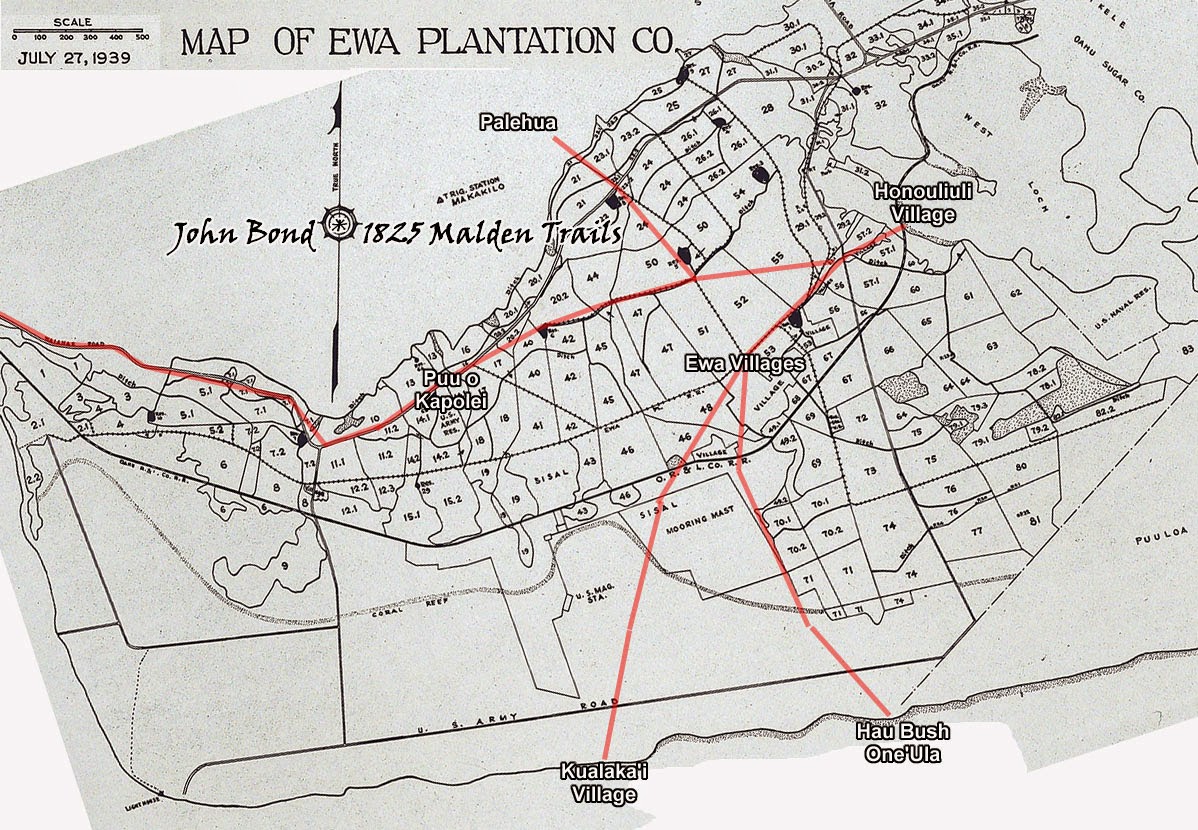
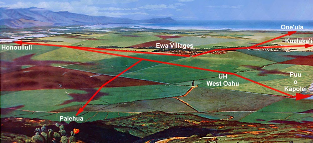
The 1825 Malden Map which clearly indicated a major native Hawaiian konohiki based civilization and political center at the time of Western contact. The largest population on Oahu lived here. 95 percent of the population was quickly wiped out by the introduction of Western diseases.

FTA and HART are NOT building a rail transportation as promised and sold to Oahu voters but instead using rail transit funds to pave over and destroy valuable farmland used for one-thousand year old continuous agriculture. HART is all about LAND DEVELOPMENT and offering it to foreign investors to profit with as they desire to the great detriment of the environment and cultural heritage of the Hawaiian natives and residents of the island of Oahu.  

What is a Section 4(f) resource? 4(f) resources include any publicly owned public park, recreation area, or wildlife or waterfowl refuge or any publicly or privately owned historic site.


The 1825 Malden Trails overlaid on the Ewa Plantation fields map. The largest and most profitable sugar plantation in Hawaii because of the top grade volcanic soil and abundant springs under the karst reef.

The sites where FTA transit funds are being used to encourage complete and total NUKING of farmland used continuously for one thousand years by native Hawaiians, over 100 years by Ewa Plantation and currently by truck farmers is really a gross violation in the use of transit funds and "taking" of  extremely valuable farmland that also serves as an emergency civil defense backup food source.

What is a "use"? In discussing 4(f), "use" may mean either a direct use or constructive use. A direct use occurs when land is permanently incorporated into a transportation facility or when there is a temporary occupancy of land that is adverse to a 4(f) resource. Constructive use occurs when a project's proximity impacts are so severe that the protected activities, features, or attributes that qualify a resource for protection under Section 4(f) are "substantially impaired".


HART Rail and FTA encouraging the complete destruction of highly valuable farmland used continuously for over 1000 years as a Traditional Cultural Property based on agriculture.

FTA transit funds are being used to build THREE rail transit stations on totally virgin open farmland that has been used continuously for one-thousand years. In addition the HART rail project is primarily a Land Development Scheme encouraging buildings, asphalt and concrete in a location where there never was an urban culture! In fact HART Rail doesn't even go to the main communities it was meant to serve (Kapolei and Ewa) and instead creates an ENTIRELY NEW sub CITY that will be called "East Kapolei" the local residents will have to commute to use the supposed local rail transit system.


What is feasible? An alternative is considered feasible if it can be constructed as a matter of sound engineering. Alternatives that are studied in a Draft Environmental Impact Statement or Environmental Assessment are almost always feasible; otherwise they should not be carried forward for detailed study.


Native Hawaiians are increasingly rediscovering their own culture that allowed them to maintain a highly successful and sustainable civilization for 1000 years. The Makahiki processions honored the god of agriculture- Lono. Today the god of Oahu is $$$ that all politicians worship.


FTA and HART continuously turned a deaf ear to years of comments and testimony pointing out historic and traditional cultural sites in the WOFH phase one segment. Rail Project effects on historic and cultural sites were intentionally SHAPED and BENT to deliver a "no effect" pronouncement by FTA.  


What is prudent? The Supreme Court has defined an alternative as not prudent only if it involves "truly unusual factors" or "unique problems" or the cost of community disruption reaches "extraordinary magnitudes". FTA uses a number of factors, including the project context and the severity of impacts to non-4(f) resources, in determining what is prudent.


West Oahu's new RED LIGHT district - where asphalt and concrete rule over sustainable agriculture.

Numerous studies including even by FTA and their contracted engineering firm that specialized in rail projects predicted that HART's "numbers and estimates" for construction costs and completion times were UNREALISTIC and NOT LIKELY based upon all previous real world transit projects. Yet HART and City officials promised "On time and on budget" which clearly isn't happening.  Among "community disruption" and "extraordinary magnitudes" is paying billions MORE for a project that was clearly a BIG LIE land development scheme from the very beginning. 


Land developers want to dump excess toxic water runoff into Pearl Harbor directly and into "holding ponds," where on the ancient karst coral reef will drain the toxic water into the ocean anyway.

The Rail Fixed Guideway could have saved BILLIONS by using modern state-of-the art MagLev rail technology used worldwide which is nearly noiseless, requires far less maintenance and uses smaller pylon supports, however the City would NOT ALLOW MagLev as an alternative rail consideration. Heavy steel on steel elevated rail requires hugely more expensive eight foot in diameter support columns and vastly higher maintenance costs. No other city in the United States would allow itself to be conned into a $300 million a mile construction con job that is really just a land development scheme. 


Real estate land speculation, greed and developer profits rule over sustainability and common sense. Oahu is in a remote Pacific location with an extremely short food supply that must be shipped in at ever increasing cost. Oahu is based upon a short term head in the sand Lemming Culture.

The HART Rail is also a highly corruption prone project that rewards city officials to continue to LIE, take large campaign donations, special gifts and rewards to push the project endlessly forward despite massive financial costs using a very regressive and ever increasing taxation system with ongoing theft of other City government services and programs.

What is least harm? FTA must consider many factors, not just acreage of a 4(f) resource used. Does the project shave an edge of a resource as opposed to cutting through the middle? Alter an historic building versus alter surrounding land? Take an unused portion or a highly used portion of a park? FTA must consider the net impacts of each alternative after mitigation measures have been taken into account. If two alternatives cause "substantially equal" harm to 4(f) resources, FTA may choose either one.


1000 year old top grade volcanic soil will be covered in asphalt and concrete forever. The Honouliuli Ewa area was once known as the "Golden Triangle" bread basket of the best native Hawaiian agricultural products and later as the most profitable sugar plantation- all a renewable annual resource which is now being completely killed off by FTA-HART funded land developers.

FTA transit funds are being used to encourage construction and development on top grade virgin open farmland soil that has been used continuously for one-thousand years with very high productivity. In addition the HART rail project is primarily a Land Development Scheme that removes a highly important emergency food supply, runs counter to the Hawaiian cultural practice of sustainability, encourages vast over building, asphalt and concrete in a location where there never was an urban culture.


A 1000 year old continuous traditional agricultural culture will be paved over forever destroying
it. Oahu has never seen a project of this scope destroying such a vast agricultural resource.

The impervious surface will create massive rain and flood control issues that will pour toxic runoff into interior waterways and preservation habitats killing endangered birds and poisoning reef fish, edible limu (algae) and the entire aquatic food chain. 

Does Section 106 of the National Historic Preservation Act duplicate 4(f)? There is overlap, but they are two different types of requirements enacted by Congress on the same day in 1966. 4(f) is a substantive standard, while Section 106 is essentially a consultative procedural requirement.


The only FTA-HART mitigation are Rail TOMBSTONES to remember the DEATH of 
a 1000 year old Honouliuli Ewa traditional sustainable Konohiki based agriculture.

FTA HART is definitely NOT applying Section 4f to the West Oahu HART rail project segment.

Who makes the 4(f) decision for (HART) rail projects? FTA decides whether Section 4(f) applies to a resource, reviews assessments of each alternative's impacts to 4(f) properties, and determines whether the law allows the selection of a particular alternative after consulting with the Department of Interior.


The FTA-HART Area of Potential Effect (APE) includes a major portion of Honouliuli Ewa's top grade Golden Triangle farm land. FTA chose to see NO EFFECT on any historic or cultural properties despite large amounts of TCP evidence and public comments. 

This is a massive act of corruption in itself for a federal agency under major political pressure at high levels to make very rushed decisions on what is or IS NOT an important historic Traditional Cultural Place or Property in order to meet very rushed construction timelines.


A Plan To Restore The 1825 Malden Mapped Ancient Hawaiian Trails On The Ewa Plain


CIA Helps Establish Honouliuli Ewa As A Traditional Cultural Property - Place


Honouliuli Ewa was once ruled by a the agricultural god Lono connected by a major trail network.

HART Rail Ewa Plain Route Drills Into Major 1000 Year Old Native Hawaiian Burial Grounds


HART Rail Ignores Signed Programmatic Agreement - Destroys Oahu Cultural Sites


Honouliuli National Register of Historic Places Criteria


The HART Rail Library Of Traditional Cultural Properties, Unidentified TCP's and TCP Meetings