Pearl Harbor-Ewa Karst Water Caves And Springs Damaged By HART Deep Rail Column Boring

Eight foot in diameter rail columns go down 150-200 feet deep into ancient water caverns holding some of South Oahu's best spring water
Many of the names of places along Pearl Harbor are for natural springs.
Kalauao Spring in Aiea is one of them... Salt Lake was hydrologically connected to the ocean, and the the subterranean caverns below Moiliili...
By John Bond Kanehili Cultural Hui
Below is what HART presented in the form of PowerPoint slides to dismiss concerns that HART rail columns would NOT be entering into karst or breaking into karst caverns. These statements are made based upon digging a few holes three feet deep into the dirt while in fact boring machines go down 150-200 feet below the surface.

HART presented this PowerPoint slide stating that "it is obvious the project
would NOT in any way impair the ground water flow within the lens since ground
water flows from mauka to makai."
This slide actually doesn't make much sense but pretends to know what
they are talking about.

Yet in meeting minutes HART actually admits:
geotechnical borings have indicated The East Kapolei station
approach penetrates into the coralline deposits. (That's because you can actually
see it three feet below the surface! However, HART rail pylon holes go
down 150-200 feet- clearly they are hitting karst and water caves along the
ENTIRE ROUTE.)
The Honolulu High-Capacity Transit Corridor Project (later HART) has falsified historic, cultural and environmental data well before beginning rail construction on the Ewa Plain. The Farm Report was falsified and effects on historic properties were completely ignored and TCP boundaries "moved" to fit their construction agenda. The environmental damage to below surface aquifers, waterways and major below surface water caves is really just beginning...

To have an idea how deep 150 to 200 feet is- know that the Statute of Liberty is 151 feet from base to torch. Even in Ewa where alluvial soil from the Waianae mountains covers part of the Ewa Plain in a relatively thin layer, The HART - Kiewit construction is drilling deep into Ewa aquifer caprock and contaminating, if not completely destroying underground waters.


Parts of Oahu have ancient reef shelves attached to the island which were formed after a period of much higher sea level well over 100,000 years ago. The Ewa and Pearl Harbor karst reef are the largest with the Ewa Plain being around 25 square miles of ancient coral reef.

At one time the sea level was 95 feet higher, then dropped, and then later rose again approximately 25 feet, leaving behind the karst terrain that created what we know today as Pearl Harbor. The Wai Momi river and hundreds of upland mauka streams of water over thousands of years dissolved caves and underground water channels. These were ideal fisheries and spawning habitats that created an enormously productive eco system.
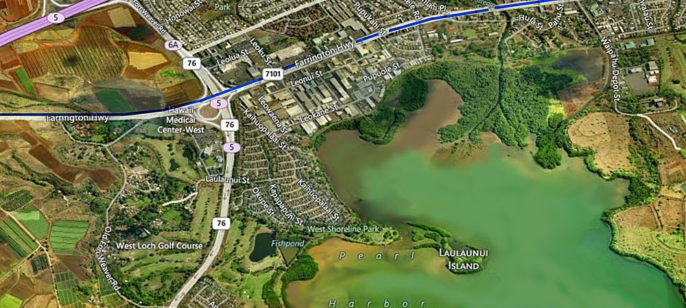
Deep eight foot in diameter bore holes 150-200 feet deep are going in all along the edge of Pearl Harbor (Farrington Highway in Waipahu) where hundreds of below surface water channels and caves are known to exist.
*****************************************************
In Older Times Salt Lake Connected To Ocean
Researched by Kumu Pono Associates LLC
for the HART Rail Project
On the way from Moanalua to town I had to pass the curious
Salt Lake which has always been an object of interest to visitors to Honolulu.
This lake was of great value to the natives in former times.
This lake is wholly separated from the sea by a
low range of hills, but the action of the tide on its waters demonstrates an
underground connection. The lake is everywhere shallow, except near the center
where a deep hole exists, which has, I believe, never been sounded with
success. Here, no doubt, is the channel of communication with the sea.
****************************************************
The Kalauao Spring included two natural springs of percolating water.
In ancient times, the springs irrigated taro loʻi
http://hawaiiindependent.net/story/sumida-farms-embraces-the-past-and-future-of-agriculture-in-hawaii
The story does NOT mention that the farm is located on a karst spring. Mineralized
water that comes from karst is very special, growing the best limu, etc. Ewa was called
the "House of Limu" because it had such a unique, delicious taste.
Ewa Plain farmland cannot be replaced it is a unique environment due to the
karst spring water that Ewa has. Places like Sumida Farms also enjoys
this special karst spring environment.
Since 1928, the Sumida family have been growing watercress in a magical spot in the heart of Aiea being fed by a natural spring. Yes, that’s their farm right besides Pearlridge, a reminder of the fact that Aiea and Pearl Harbor were once a breadbasket and important fishing grounds.
“Wait until you taste the spring water,” one of the Slow Food veterans told us. I was slightly taken aback; I didn’t see any drinking water around.
When Operations Manager and tour guide David Sumida waded into the stream and proceeded to cup a large gulp with his hands, I was shocked to think that water at one’s feet could be clean enough to drink. Granted, I’m a total townie, but to be fair to myself, I was looking at Sears next door!
It turns out the reason the farm is located where it is due to the abundance of spring water around Pearl Harbor. There are twelve watercress farms in Oahu, each growing a different variety of watercress, but all twelve are in the vicinity of the Pearl Harbor Spring
(the rest around Pearl City and Waipahu).
Sumida Farm is the furthest east of these farms, and therefore has the highest water quality from the spring.
**************************************************
Fish tales spring from
Moiliili sinkholes
By June Watanabe Honolulu Star-Bulletin
Oldtimers remember when the Standard Trading store, located just about where
Central Pacific Bank in University Square is, actually "just fell in." This was in 1952.
Even earlier, Sidney Kashiwabara, who grew up in Moiliili, remembers "three separate
locations where the ground gave way, leaving gaping holes in which we could enter
and explore the subterranean caverns below Moiliili."
• The coral and marine sediment caprock in blue confines the basal water
from leaking out into the oceans. Caprock areas were submerged in the past.
http://www.hbws.org/files/ewawmp_communitymtg1_slideshow_may212013_withnotes.pdf


The Pearl Harbor embayment, along the south coast, formed as the island sank ~360 m toward the end of the main shield building phase, drowning the river valleys that drain central O‘ahu. Pearl Harbor contains almost 50 km of shoreline backed by extensive wetlands through which highly sedimented waters enter the harbor. The coastal plains to the west and east of Pearl Harbor, ‘Ewa and Honolulu, lie atop a broad coral reef platform from the late Pleistocene last interglacial that developed during interglacial periods of warmer waters and higher relative sea level.
McBryde Sugar Company vs. Robinson involved a dispute between two sugar plantations over surplus water rights to the Koala Stream and Hanapepe River on the Island of Kauai. The Hawaii Supreme Court ruled that although the parties had rights to use water, they had no ownership interest in the water itself. This landmark ruling put Hawaii's water resources in the public trust to be managed for the benefit of present and future generations and ensured that no water could be transferred out of the watershed area (Wilcox, 1997).
1978
Hawaii's Constitution (1978) was amended by voter approval to establish a new framework for water resource management under Article XI. This further solidified that all public natural resources are held in trust by the State for the benefit of the people and future generations.
1987
Hawaii's State Water Code recognizes the following four specific rights to ground and surface water:
Appurtenant rights: Protects land that was cultivated by traditional crops before the colonization period, such as taro that requires a necessary amount of water to cultivate. Rights are attached to the land, not an individual. This right receives the highest level of protection under Hawaiian law and is considered a public trust purpose.
Native Hawaiian rights: Reinstates Article XII Section 7 of the Hawaii Constitution that states, "The State reaffirms and shall protect all rights, customarily and traditionally exercised for subsistence cultural and religious purposes and possessed by ahupua'a (see Hawaiian Cultural Beliefs page) tenants who are descendants of native Hawaiians prior to 1778..."
Riparian rights: Protects the interests of people who live near a river or stream to reasonably use that riparian surface water source. Appurtenant and Native Hawaiian rights supersede riparian rights. Existing riparian rights cannot be severed from the riparian land regardless of sale or designated water management areas, however riparian landowners who are not using water currently from an adjacent stream may or may not be granted a new permit.
Correlative rights: Protects the interests of people who own land over a ground water source or fresh water aquifer. The land has rights that correlate to the water below it.
(Miike, 2004)
References
Board of Water Supply, City and County of Honolulu. Ka Wai Ola: Water for Life. Integrated collaborative watershed management:
Constitution of the State of Hawaii, Article XI, Constitutional Revision (1978). Retrieved from: http://hawaii.gov/lrb/con/conart11.html
Miike, L.H. (2004). Water and the law in Hawaii. Honolulu, HI. University of Hawaii Press.
Moanalua Gardens Foundation (2003). Plunging into the water cycle. (p. 4). Retrieved from:
Improving water planning and management. July 20, 2009.
Sproat, D.K. (2009). Ola i Ka Wai: A legal primer for water use and management in Hawaii. Honolulu, HI: Ka Huli Ao Center for Excellence in Native Hawaiian Law.


locations where the ground gave way, leaving gaping holes in which we could enter
and explore the subterranean caverns below Moiliili."
************************************************
Page 111
4.9.2 Natural Environment
During the Pleistocene Sangamon Interglacial Stage (130,000 to 114,000 years
ago), the sea level was at least 25 feet higher than today (Stearns 1978). This led to
the deposit of fossil reef limestone in south coastal Oahu. The rise and retreat of the
sea level led to the formation of interbedded marine and terrestrial deposits miles inland. This limestone, called the Moiliili Karst, is composed of detritus, calcareous sand, reef-dwelling organisms, and coralline algae. Alluvium and marshy lagoon sediments eventually
The Moiliili Karst is subject to dissolution from water and has formed a series of
connected and isolated caves under the Moiliili area. The caves were probably
once one large interconnected cave or series of caves about 0.5 miles long.
Subsequent construction in this area, involving extensive dewatering and filling,
damaged the cave system. In the Moiliili area, only one section called the
Page 111
4.9.4 Past Land Use and Land Commission Awards Information
The marshland of Waikiki was watered from streams in the Makiki, Manoa, and
'Nolo Valleys. The well watered, fertile and relatively level lands of Manoa Valley
supported extensive wet taro cultivation from pre-contact times well into the 20th
century. Additionally, the abundance of water promoted the dissolution of the Mo'iliili Karst,
Page 132
5.1.1 Honouliuli Sub-Area (partially within planned extension)
Background research has indicated that the well-watered, fertile lands of Manoa
were used extensively for wet taro cultivation in pre-contact times and into the 20th
century, and also used for other types of crops such as bananas and a variety of vegetables. The springs and ponds created in the Mo'iliili Karst provided abundant available water and were used by traditional Hawaiians for drinking water, irrigation, and aquaculture during pre-contact and early post-contact times.
In the beginning of the 19th century, the taro lands and fishponds, including those of the
or buried any surface archaeological resources that may have been present.
However, it is likely that archaeological resources in the form of subsurface cultural
deposits are present beneath modern development. These subsurface deposits
could contain pre-contact and post-contact archaeological resources. Pre-contact
subsurface deposits could include fishpond and taro cultivation sediments,
alignments or walls associated with fishponds and taro cultivation, and buried living
surfaces containing midden, artifacts, and hearth features.

A USGS map of West Loch and Middle Loch shows the feet above sea level averages 20-40 feet. HART rail construction is right down the center of Farrington Highway - so they are hitting Karst caprock in a short distance down as well as likely contaminating the water that flows into Pearl Harbor.
The Board of Water Supply maps show this as coral Caprock. That's because all of Pearl Harbor was
a reef round 120,000 years ago. The Pearl River eroded the reef to create the Pearl Harbor lochs. You can still see the ancient coral reef if you visit the Pearl Harbor shoreline.
HART Rail construction is endangering South Oahu's natural caprock. Drilling down 150-200 feet clearly fractures and punctures the caprock, allowing Oahu's precious natural water storage in caprock to leak away.
USGS Map of the Ewa Plain shows that drilling down 150 feet will clearly hit the ancient coral Karst reef which rests on the side of the Waianae volcano. This punctures and fractures the ancient
reef which acts as a huge water storage system. If it gets broken it will allow salt water to enter and destroy Ewa's natural caprock water storage.
Note that HCDA chairman Tony Ching described the "underground rivers" in an interview with a special Sunday feature of the Honolulu Star-Bulletin about the Kalaeloa Heritage Park.
FROM Honolulu Board of Water Supply:
The overall goal of the Oahu Watershed Management Plan (OWMP) reflects community, landowner, BWS and other agency values, issues, and concerns.
Oahu’s hydro-geology is made up of three major formations:
• Basal aquifers of the central corridor and in Honolulu.
• High-level dikes along the crests of the Koolau and Waianae mountains.
The dikes are smaller in volume than the basal aquifers and therefore are
more prone to drought.
Archaeological Resources Technical Report August 15, 2008
Honolulu High-Capacity Transit Corridor Project AR00037676
Pages where “Karst” is specifically mentioned. However “Karst” is also described in many other pages as “coral outcrop,” and many other related words which are also ancient coral reef Karst.
All of this information about the Moiliili Karst also applies to all karst in Ewa, Pearl Harbor and along the south shoreline into Honolulu which is all ancient limestone coral reef.
4.9.2 Natural Environment
ago), the sea level was at least 25 feet higher than today (Stearns 1978). This led to
the deposit of fossil reef limestone in south coastal Oahu. The rise and retreat of the
sea level led to the formation of interbedded marine and terrestrial deposits miles inland. This limestone, called the Moiliili Karst, is composed of detritus, calcareous sand, reef-dwelling organisms, and coralline algae. Alluvium and marshy lagoon sediments eventually
accumulated on top of the Moiliili Karst.
connected and isolated caves under the Moiliili area. The caves were probably
once one large interconnected cave or series of caves about 0.5 miles long.
Subsequent construction in this area, involving extensive dewatering and filling,
damaged the cave system. In the Moiliili area, only one section called the
Moiliili Water Cave can still be accessed.
4.9.4 Past Land Use and Land Commission Awards Information
'Nolo Valleys. The well watered, fertile and relatively level lands of Manoa Valley
supported extensive wet taro cultivation from pre-contact times well into the 20th
century. Additionally, the abundance of water promoted the dissolution of the Mo'iliili Karst,
creating springs and ponds that were used by Native Hawaiians for drinking
water, irrigation, and aquaculture during pre-contact and early post-contact periods.5.1.1 Honouliuli Sub-Area (partially within planned extension)
Also of note is the makai and 'Ewa portion of this sub-area, which is situated within a karst
limestone plain that contains numerous dissolution pit caves that were used by pre-contact
Hawaiians for water catchment, planting, and temporary habitation. These sinkholes also contain paleontological information from several extinct birds identified by recovered bones.
Page 142
5.1.9 Manoa Sub-Area (planned extension)were used extensively for wet taro cultivation in pre-contact times and into the 20th
century, and also used for other types of crops such as bananas and a variety of vegetables. The springs and ponds created in the Mo'iliili Karst provided abundant available water and were used by traditional Hawaiians for drinking water, irrigation, and aquaculture during pre-contact and early post-contact times.
Mo'iliili Karst, were filled to provide land for housing and commercial activities.
These land reclamations and subsequent urban development would have destroyedor buried any surface archaeological resources that may have been present.
However, it is likely that archaeological resources in the form of subsurface cultural
deposits are present beneath modern development. These subsurface deposits
could contain pre-contact and post-contact archaeological resources. Pre-contact
subsurface deposits could include fishpond and taro cultivation sediments,
alignments or walls associated with fishponds and taro cultivation, and buried living
surfaces containing midden, artifacts, and hearth features.
****************************************************
The Ewa Plain is shown to be an extremely large and generally flat terrain of karst reef called "caprock" for water storage purposes. Different grades of water can be used for public drinking or for agricultural purposes, depending upon how much salt content it contains.
The Board of Water Supply maps show this as coral Caprock. That's because all of Pearl Harbor was
a reef round 120,000 years ago. The Pearl River eroded the reef to create the Pearl Harbor lochs. You can still see the ancient coral reef if you visit the Pearl Harbor shoreline.
HART Rail construction is endangering South Oahu's natural caprock. Drilling down 150-200 feet clearly fractures and punctures the caprock, allowing Oahu's precious natural water storage in caprock to leak away.
USGS Map of the Ewa Plain shows that drilling down 150 feet will clearly hit the ancient coral Karst reef which rests on the side of the Waianae volcano. This punctures and fractures the ancient
reef which acts as a huge water storage system. If it gets broken it will allow salt water to enter and destroy Ewa's natural caprock water storage.
Note that HCDA chairman Tony Ching described the "underground rivers" in an interview with a special Sunday feature of the Honolulu Star-Bulletin about the Kalaeloa Heritage Park.
FROM Honolulu Board of Water Supply:
The overall goal of the Oahu Watershed Management Plan (OWMP) reflects community, landowner, BWS and other agency values, issues, and concerns.
Oahu’s hydro-geology is made up of three major formations:
• Basal aquifers of the central corridor and in Honolulu.
• High-level dikes along the crests of the Koolau and Waianae mountains.
The dikes are smaller in volume than the basal aquifers and therefore are
more prone to drought.
• The coral and marine sediment caprock in blue confines the basal water
from leaking out into the oceans. Caprock areas were submerged in the past.
http://www.hbws.org/files/ewawmp_communitymtg1_slideshow_may212013_withnotes.pdf
********************************************************************


****************************************************************


****************************************************************
Honolulu’s Little Known Karst History

The Pokukaina royal burial sites at Iolani Palace is actually an ancient sacred karst cave
The Pokukaina royal burial sites at Iolani Palace is actually an ancient sacred karst cave
Iolani Barracks was constructed with over 4,000 ancient coral reef blocks.
Ancient Coral Reef Karst also makes up the structure of Iolani Palace in Honolulu which in ancient times was known as Kou.
The ancient coral reef karst is easy to see in the construction of Kawaiahao Church - "Ka wai a
Haʻo" (the water of Haʻo).
Prior to the missionaries arriving in the islands, what became Honolulu was a flat plain of ancient coral reef known today as Karst. In one area there was an oasis, a spring whose waters were reserved exclusively for the land's high chiefs and chiefesses.
One such noble who frequented this pool was the chiefess Ha‘o. Eventually these waters, and the surrounding land, came to be known as Ka Wai a Ha‘o-the freshwater pool of Ha‘o.
Kawaiahao Church still maintains a spring like fountain on the grounds.
The ancient coral reef limestone rock that was found next to the spring has been incorporated into the existing foundation that commemorates the spring. (Located in front of the sanctuary, at the main entrance to the grounds)
The Mission Houses museum has buildings built from the karst reef which go back to 1831 and 1841.
The Cathedral of Our Lady of Peace Church is another karst block construction in Honolulu.
Much of Honolulu’s shoreline
once looked like this- which is still seen all over the
Ewa shoreline and parts of Pearl Harbor as well as along the Waianae coast. In fact
the entire subsurface of Ewa is karst, as is much of makai Honolulu.

Summary of Ground Water Protection Laws
The Pearl Harbor embayment, along the south coast, formed as the island sank ~360 m toward the end of the main shield building phase, drowning the river valleys that drain central O‘ahu. Pearl Harbor contains almost 50 km of shoreline backed by extensive wetlands through which highly sedimented waters enter the harbor. The coastal plains to the west and east of Pearl Harbor, ‘Ewa and Honolulu, lie atop a broad coral reef platform from the late Pleistocene last interglacial that developed during interglacial periods of warmer waters and higher relative sea level.
Hawaii Water Rights
1973McBryde Sugar Company vs. Robinson involved a dispute between two sugar plantations over surplus water rights to the Koala Stream and Hanapepe River on the Island of Kauai. The Hawaii Supreme Court ruled that although the parties had rights to use water, they had no ownership interest in the water itself. This landmark ruling put Hawaii's water resources in the public trust to be managed for the benefit of present and future generations and ensured that no water could be transferred out of the watershed area (Wilcox, 1997).
1978
Hawaii's Constitution (1978) was amended by voter approval to establish a new framework for water resource management under Article XI. This further solidified that all public natural resources are held in trust by the State for the benefit of the people and future generations.
1987
Hawaii's State Water Code recognizes the following four specific rights to ground and surface water:
Appurtenant rights: Protects land that was cultivated by traditional crops before the colonization period, such as taro that requires a necessary amount of water to cultivate. Rights are attached to the land, not an individual. This right receives the highest level of protection under Hawaiian law and is considered a public trust purpose.
Native Hawaiian rights: Reinstates Article XII Section 7 of the Hawaii Constitution that states, "The State reaffirms and shall protect all rights, customarily and traditionally exercised for subsistence cultural and religious purposes and possessed by ahupua'a (see Hawaiian Cultural Beliefs page) tenants who are descendants of native Hawaiians prior to 1778..."
Riparian rights: Protects the interests of people who live near a river or stream to reasonably use that riparian surface water source. Appurtenant and Native Hawaiian rights supersede riparian rights. Existing riparian rights cannot be severed from the riparian land regardless of sale or designated water management areas, however riparian landowners who are not using water currently from an adjacent stream may or may not be granted a new permit.
Correlative rights: Protects the interests of people who own land over a ground water source or fresh water aquifer. The land has rights that correlate to the water below it.
(Miike, 2004)
References
Board of Water Supply, City and County of Honolulu. Ka Wai Ola: Water for Life. Integrated collaborative watershed management:
Constitution of the State of Hawaii, Article XI, Constitutional Revision (1978). Retrieved from: http://hawaii.gov/lrb/con/conart11.html
Miike, L.H. (2004). Water and the law in Hawaii. Honolulu, HI. University of Hawaii Press.
Moanalua Gardens Foundation (2003). Plunging into the water cycle. (p. 4). Retrieved from:
Improving water planning and management. July 20, 2009.
Sproat, D.K. (2009). Ola i Ka Wai: A legal primer for water use and management in Hawaii. Honolulu, HI: Ka Huli Ao Center for Excellence in Native Hawaiian Law.
Karst Caves can still be
found throughout Kalaeloa as it was the least disturbed Ewa area and used
primarily for Navy and Marine WW-II airfields. These caves were formed by fresh
water flowing through ancient reefs, which dissolved channels, caverns and
sinkholes.